基本情報
出展製品・サービス
「Trimble SX12」&「Trimble Access」
Scanning Total station「Trimble SX12」 Field Software「Trimble Access」
Trimble SX12 は、サーボトータルステーションと地上型レーザースキャナーを高精度・高性能で融合させた唯一無二のスキャニングトータルステーションです。
フィールド用ソフトウェア「Trimble Access」と連携することで、スキャンはもちろん、3DモデルやCAD図面を高精度なAR(拡張現実)で投影し、計測を行うことができます。
可視化による測量は誰でもわかりやすく、効率良く作業できます。スキャンデータは、設計データとその場で比較して、ヒートマップ表示やレポート作成も可能。
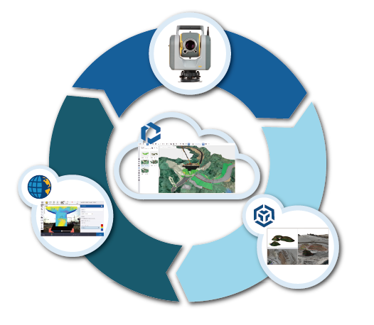
観測データはクラウドシステム「Trimble Connect」、や「Trimble Business Center」とクラウド連携し、データ共有ができます。内業と外業の連携を加速させ、作業効率が格段に向上します。
The Trimble SX12 is a unique scanning total station that seamlessly integrates a servo total station with a terrestrial laser scanner, delivering exceptional precision and high performance.
By working together with the field software “Trimble Access,” it enables not only scanning but also the projection of 3D models and CAD drawings with highly accurate augmented reality (AR) for measurement tasks.
Visualization-based surveying makes the workflow intuitive and highly efficient for anyone. The scan data can be immediately compared with design data on-site, allowing for heatmap visualization and report generation.
Observation data can be shared through cloud-based systems such as “Trimble Connect” and “Trimble Business Center.” This seamless integration between field and office significantly accelerates collaboration and greatly improves work efficiency.
3次元モデリングソフトウェア「SketchUp」
3D Modeling Software「SketchUp」
SketchUpは、Trimble社が提供する3Dモデリングソフトウェアです。
直感的な操作性と高い柔軟性を持ち、建築、インテリアデザイン、ランドスケープデザインなど、さまざまな分野で広く利用されており、世界中に100万人以上のユーザーに利用されている3Dモデリングソフトウェアです。
SketchUpは、3Dモデルを簡単に作成し、視覚化するための強力なツールを提供します。
主な特徴としては以下の点が挙げられます。
・直感的な操作性:初心者でも簡単に使えるインターフェース。
・多様なプラットフォーム対応:Windows、Mac、Web版、iPad版など、さまざまなデバイスで利用可能。
・豊富なリソース:3D Warehouseを通じて、数百万の無料モデルにアクセス可能。
・高品質なビジュアライゼーション:リアルなマテリアルと環境設定で、説得力のあるプレゼンテーションを作成。
更に2025年2月にリリースされた「SketchUp 2025」ではよりリアルな表現を可能にするためにビジュアル性能の向上、IFC、Revitデータなど各種データとの連携強化、3D Warehouseコンテンツの拡充など様々な機能向上が行われております。プロフェッショナルから趣味のユーザーまで、幅広い層に支持されており、クリエイティブなアイデアをすぐに具現化できる点が魅力な3Dモデリングソフトウェアです。
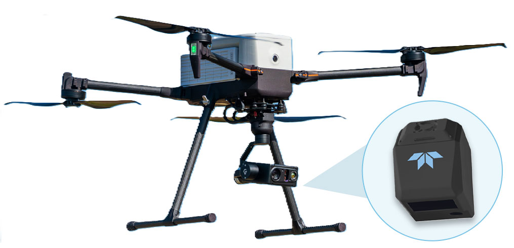
TEKEDYNE EchoONE Powered by Inertial Labs RESEPI Secure Lightweight Airborne Laser Scanner
TELEDYNE GEOSPATIAL EchoONE は、Teledyne Geospatial が提供する、軽量かつ高いセキュリティ性を備えたUAV搭載型の航空レーザースキャナーです。
DJI Matrice 300 RTK / DJI Matrice 350 RTK、Freefly Astro、Inspired Flight IF800 などのドローンに対応しています。土地測量、電力インフラの植生管理・設備管理、交通インフラプロジェクトなどの用途において、EchoONEは高精度かつカラー化されたエンジニアリンググレードのLiDAR点群データを安全に取得します。
NDAA準拠 / データセキュリティ
EchoONEは、FY2020 NDAA Sec 848 および FY2023 NDAA Sec 817 に準拠しています。
データの安全性およびセキュリティが求められるプロジェクトにも対応できるよう、設計・開発・製造されています。
長距離LiDARと優れた植生透過性能
EchoONEは、20%反射率のターゲットに対して最大270mの測距が可能な高出力のアイセーフレーザーを搭載しています。
高高度から広範囲を迅速にマッピングする柔軟性、電力用導体や電線を捕捉する能力、樹木構造と地表の両方からの反射波を用いて密生した植生を透過する能力
The TELEDYNE GEOSPATIAL EchoONE is a secure
lightweight airborne laser scanner compatible with UAVs
such as the DJI M300/M350, Freefly Astro, Inspired Flight
IF800, and others. For applications such as land surveying,
electric utility vegetation management and asset management,
and transportation projects, the EchoONE delivers secure,
colorized engineering-grade lidar point clouds.
NDAA COMPLIANT / DATA SECURITY
EchoONE is compliant with FY2020 NDAA Sec 848 and
FY2023 NDAA Sec 817
• EchoONE is designed, developed and manufactured to be
compliant with projects requiring the safety and security
of data
LONG-RANGE LIDAR AND CANOPY PENETRATION
Powerful eye-safe laser with 270 m range to 20%
reflectivity targets
• Flexibility to map large areas quickly from a high operating
altitude, capture narrow electric utility conductors or wires,
and penetrate thick vegetation with returns from both tree structure and ground