基本情報
GNSSと空間データを活用し、建設重機、施工管理、交通解析への展開を提案。UC-1、FEM解析、UC-win/Road、ForumSync、F8-AIを統合したシミュレーション環境を紹介。
出展製品・サービス
UC-win/Road デジタルツイン・シミュレーション
UC-win/Road Digital Twin and Simulation Platform
UC-win/Roadは、都市・道路・交通などの空間をリアルタイム3Dで再現するデジタルツイン・シミュレーションミドルウェアです。都市空間をデジタルツインとして再現し、建設分野における計画・設計・施工の可視化やシミュレーションを可能にします。道路設計や都市計画、交通計画などの建設分野で広く利用されており、計画の可視化や交通流・人流のシミュレーション、防災・避難計画の検討など多様な用途に対応しています。GNSSデータや各種センサーデータと連携することで、現実空間の情報をデジタル空間に再現し、インフラ計画や都市運用の高度化を支援します。またWebGL技術を活用したメタバース環境へのデータ提供にも対応しており、ブラウザ上での3D空間共有や遠隔での情報共有を可能にします。自治体での都市計画、防災シミュレーション、観光やスマートシティ施策などにも活用されており、建設DXを支えるデジタルツイン基盤として幅広い分野で利用されています。
UC-win/Road is a digital twin simulation middleware that reproduces urban environments, roads, and transportation systems in real-time 3D. The platform enables visualization and simulation for planning, design, and construction processes by recreating real-world environments as digital twins. It is widely used in construction-related fields such as road design, urban planning, and traffic engineering. The software supports a wide range of applications including visualization of construction projects, traffic and pedestrian flow simulation, and disaster evacuation planning.
By integrating GNSS data and various sensor data, UC-win/Road synchronizes real-world environments with digital models, enabling advanced infrastructure planning and urban operation. The platform also supports WebGL-based metaverse environments, allowing browser-based 3D visualization and remote collaboration through shared digital spaces.
UC-win/Road is also used by local governments for urban planning, disaster prevention simulations, tourism visualization, and smart city initiatives. As a digital twin platform supporting construction DX, it provides a powerful foundation for infrastructure planning, visualization, and simulation.

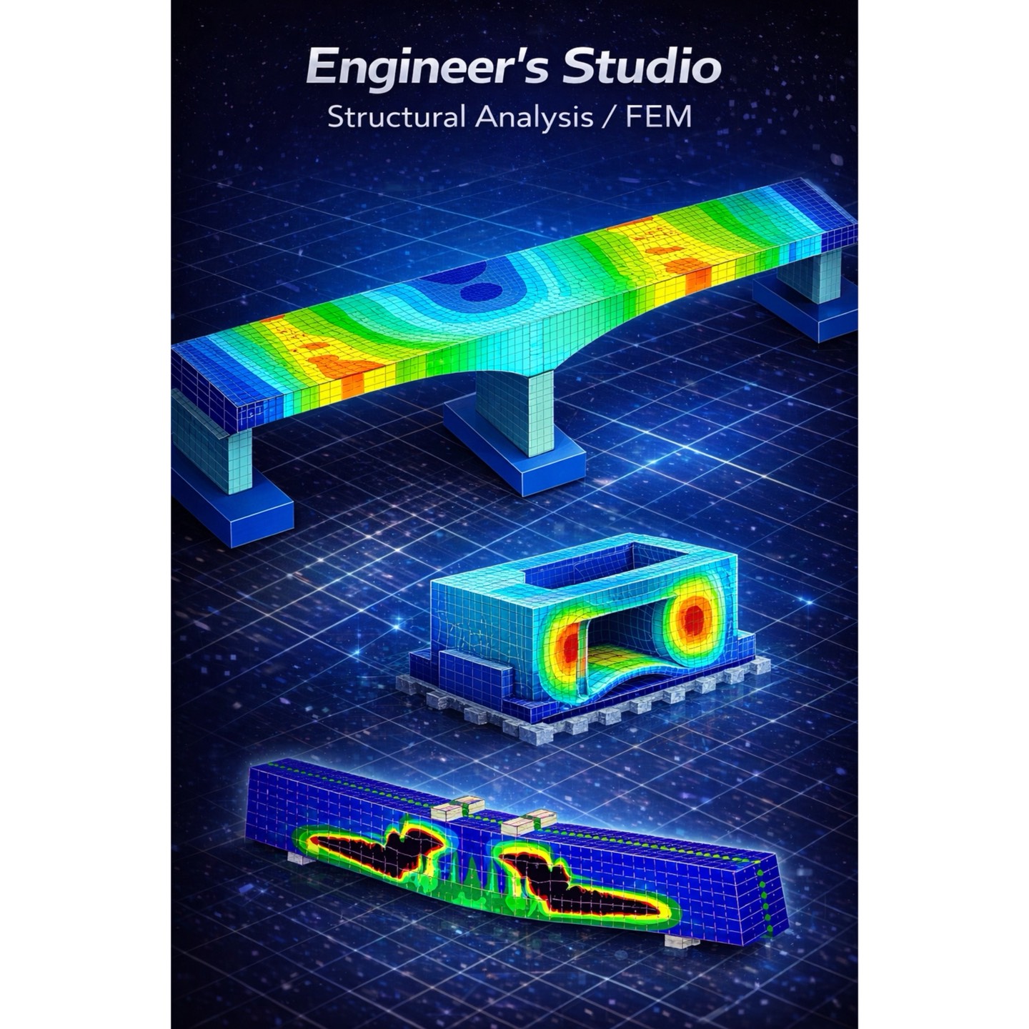
UC-1シリーズ / FEM解析ソフト(BIM/CIM対応)
UC-1 Series Structural and FEM Analysis Software for BIM/CIM
UC-1シリーズ、Engineer’s Studio、FEMLEEGは、橋梁や各種土木構造物の設計・解析を行うエンジニアリングソフトウェアです。構造設計計算、耐震設計、FEM解析など幅広い解析機能を備えており、橋梁設計やインフラ設計の分野で広く利用されています。高度な非線形解析や動的解析に対応し、構造物の安全性評価や耐震性能の検証などを行うことが可能です。またBIM/CIM環境との連携により、設計・解析・可視化を統合したエンジニアリング環境を構築し、建設プロジェクト全体の効率化と高度化を支援します。設計計算から解析、シミュレーションまでを一体的に活用することで、建設DXを支えるインフラ設計基盤として活用されています。
The UC-1 Series together with Engineer’s Studio and FEMLEEG provides advanced engineering software for structural design and FEM analysis of bridges and civil infrastructure. The software supports structural design calculations, seismic design, and advanced nonlinear FEM analysis. Widely used in bridge engineering and infrastructure design projects, it enables engineers to evaluate structural safety, analyze complex structural behavior, and verify seismic performance. The software also supports BIM/CIM workflows, integrating design, structural analysis, and visualization into a unified engineering environment. By connecting design calculations with advanced analysis and simulation, the platform supports construction DX and modern infrastructure design processes.
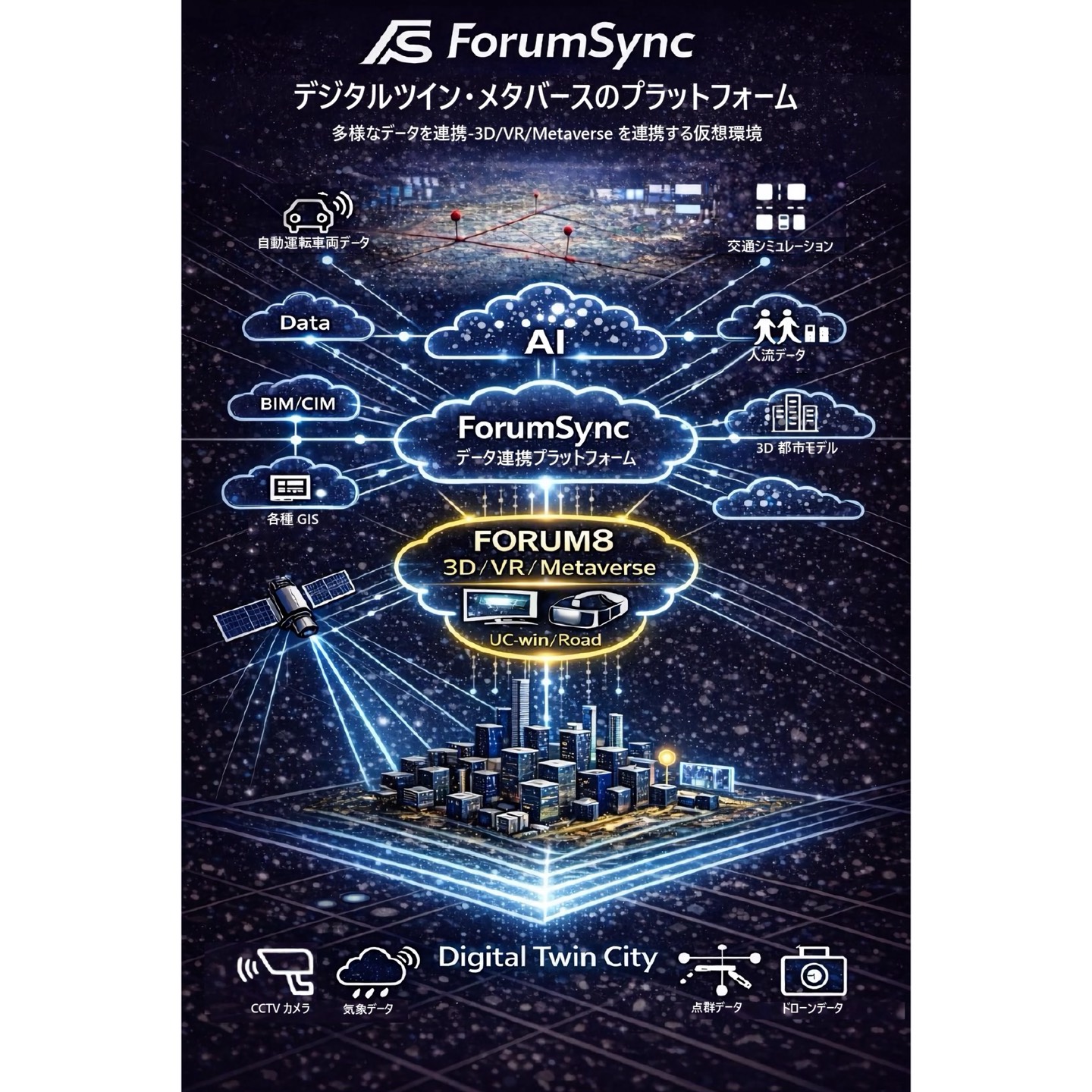
ForumSync データ連携プラットフォーム(BIM/CIM連携)
ForumSync Data Integration Platform for BIM/CIM
ForumSyncは、建設分野の各種データを統合するデータ連携プラットフォームです。設計データ、シミュレーションデータ、IoTセンサーデータなどを統合し、都市・交通・インフラのデジタルツイン環境を構築します。BIM/CIMデータとの連携により、設計・施工・維持管理に関わる情報を統合管理し、建設プロジェクト全体の可視化とデータ活用を可能にします。UC-win/Roadなどのシミュレーションソフトと連携することで、インフラの可視化や分析、運用シミュレーションなどを実現します。建設DXを支えるデータ統合基盤として、スマートシティやインフラ管理など幅広い分野で活用されています。
ForumSync is a data integration platform designed to connect engineering, simulation, and infrastructure data. It integrates design data, simulation data, and IoT sensor data to support digital twin environments for urban and infrastructure systems. By supporting BIM/CIM data integration, ForumSync enables unified management of design, construction, and maintenance information throughout the entire project lifecycle. When connected with simulation platforms such as UC-win/Road, it enables visualization, analysis, and operational simulation of infrastructure systems. As a core data platform for construction DX, ForumSync supports smart city development and advanced infrastructure management.