基本情報
出展製品・サービス
MMS&地中レーダーを用いたインフラ点検
Infrastructure inspection using MMS and ground penetrating radar
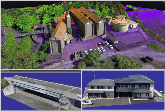
コバコンは、道路維持管理業務などにおいて、世界最高水準のMMS(Pegasus TRK700 Evo)と二重偏波によるマルチチャンネル地中レーダーを活用しております。MMSの精度は、RTK:12mm、後処理:11mmです。システムの特長は、前後に2台のSLAMレーザが搭載されており、非GNSS下では、軌跡データを補正でき、安定した精度でMMSを運用できます。位相差レーザスキャナは2台搭載されており、200万点/秒でスキャンできるため、インフラ点検などに必要な高密度、高精度計測が可能です。マルチチャンネル地中レーダーは200~1000MHzまでの広帯域信号をリアルタイムで処理することで「深度範囲の拡大」、「超高分解能」の計測が可能となります。また、MMSと車載型の地中レーダーを併用することで一度に地上と地下の計測し、統合データの精度向上を図ることができます。この展示では、MMS、地中レーダーの精度検証・計測事例等および今後のインフラDXサービス展開について説明します。
Kobacon utilizes world-class MMS (Pegasus TRK700 Evo) and dual-polarization multi-channel ground penetrating radar in road maintenance and other operations. The MMS accuracy is RTK: 12mm, post-processing: 11mm. A key feature of the system is the inclusion of two SLAM lasers, one at the front and one at the rear, which can correct trajectory data in non-GNSS environments, enabling stable and accurate MMS operation. Two phase-difference laser scanners are also installed, capable of scanning 2 million points per second, allowing for high-density, high-precision measurements necessary for infrastructure inspections. The multi-channel ground penetrating radar processes wideband signals from 200 to 1000MHz in real time, enabling "expanded depth range" and "ultra-high resolution" measurements. Furthermore, by using MMS in conjunction with vehicle-mounted ground penetrating radar, simultaneous measurements of both above-ground and underground areas can be performed, improving the accuracy of integrated data. This exhibit will explain accuracy verification and measurement examples of MMS and ground penetrating radar, as well as future infrastructure DX service developments.
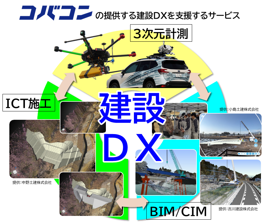
建設DXの取り組み
Initiatives for Construction DX
SLAM技術を用いた3次元測量は、容易な計測手法である一方、測量現場においては再現性が低く、計測精度や品質は環境条件に大きく依存する傾向があります。本展示では、SLAMに不向きとされる環境下での「Hovermap STX」の計測精度の検証結果をご紹介し、建設DXの推進に向けた現場作業の効率化への具体的な取り組みについてご説明いたします。
建設現場では、BIM/CIMをはじめとするデジタルデータの活用により、作業の効率化や省人化が進められています。コバコンでは、3次元モデルや点群データなど各種3次元データの計測から作成までを一貫して支援しております。現場のニーズに応じた最適なご提案をいたしますので、ぜひお気軽にご相談ください。
While 3D surveying using SLAM technology enables quick and efficient data acquisition, it tends to have lower reproducibility in field applications, with measurement accuracy and quality highly dependent on environmental conditions. At our exhibit, we will present verification results of the measurement accuracy of the “Hovermap STX” in environments considered unsuitable for SLAM, and introduce our concrete initiatives aimed at improving on-site operational efficiency as part of Construction DX.
In the construction industry, efforts to enhance productivity and reduce labor requirements are being accelerated through the utilization of digital data such as BIM/CIM. Kobacon Co., Ltd. provides comprehensive support for the entire workflow, from data acquisition to the creation of various types of 3D data, including 3D models and point cloud data. We offer optimal solutions tailored to on-site needs, so please feel free to contact us for further information.
iTwinCaptureの応用例
Examples of iTwinCapture applications
Bentley社の写真測量用ソフトウェア「iTwinCaptureModeler」は、構造物などの形状計測を詳細にモデル化できる特徴があります。さらに、iTwinCaptureは、スキャナーから得られた点群データも使って3Dモデル(メッシュ)を高精度かつリアルに生成します。
本展示では、iTwinCaptureソフトウェアを使用して、写真解析の流れと新機能3DGSおよび文化財などの応用例についてご紹介します。
Bentley’s photogrammetry software, "iTwinCaptureModeler," is characterized by its ability to model the shapes of structures and other objects in detail. Furthermore, iTwinCapture generates highly accurate and realistic 3D models (meshes) using point cloud data obtained from scanners.
This exhibit will demonstrate the photoanalysis process using iTwinCapture software, as well as application examples such as 3DGS and cultural heritage.