基本情報
出展製品・サービス
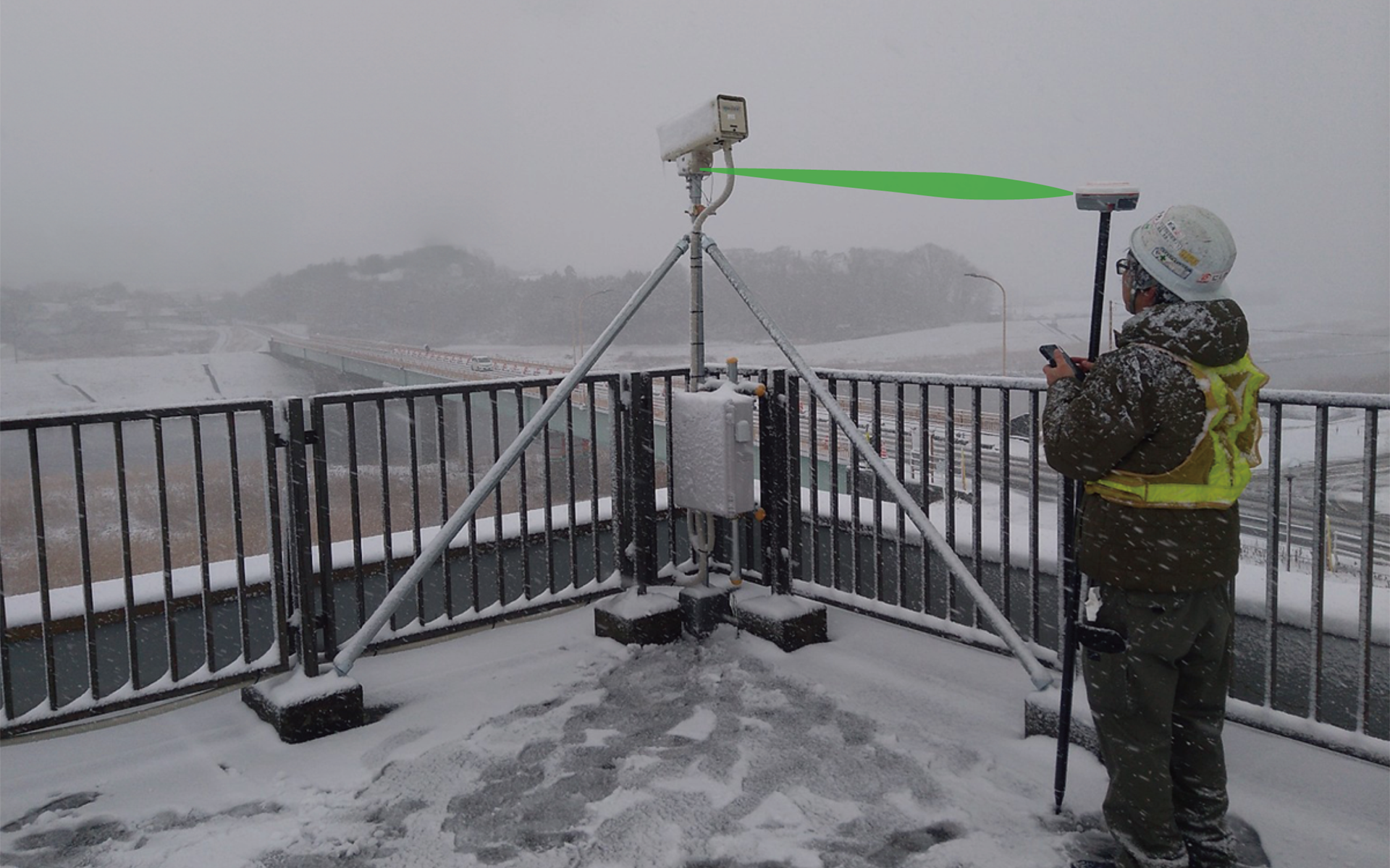
LS600 レーザースキャナー
LS600 Laser Scanner
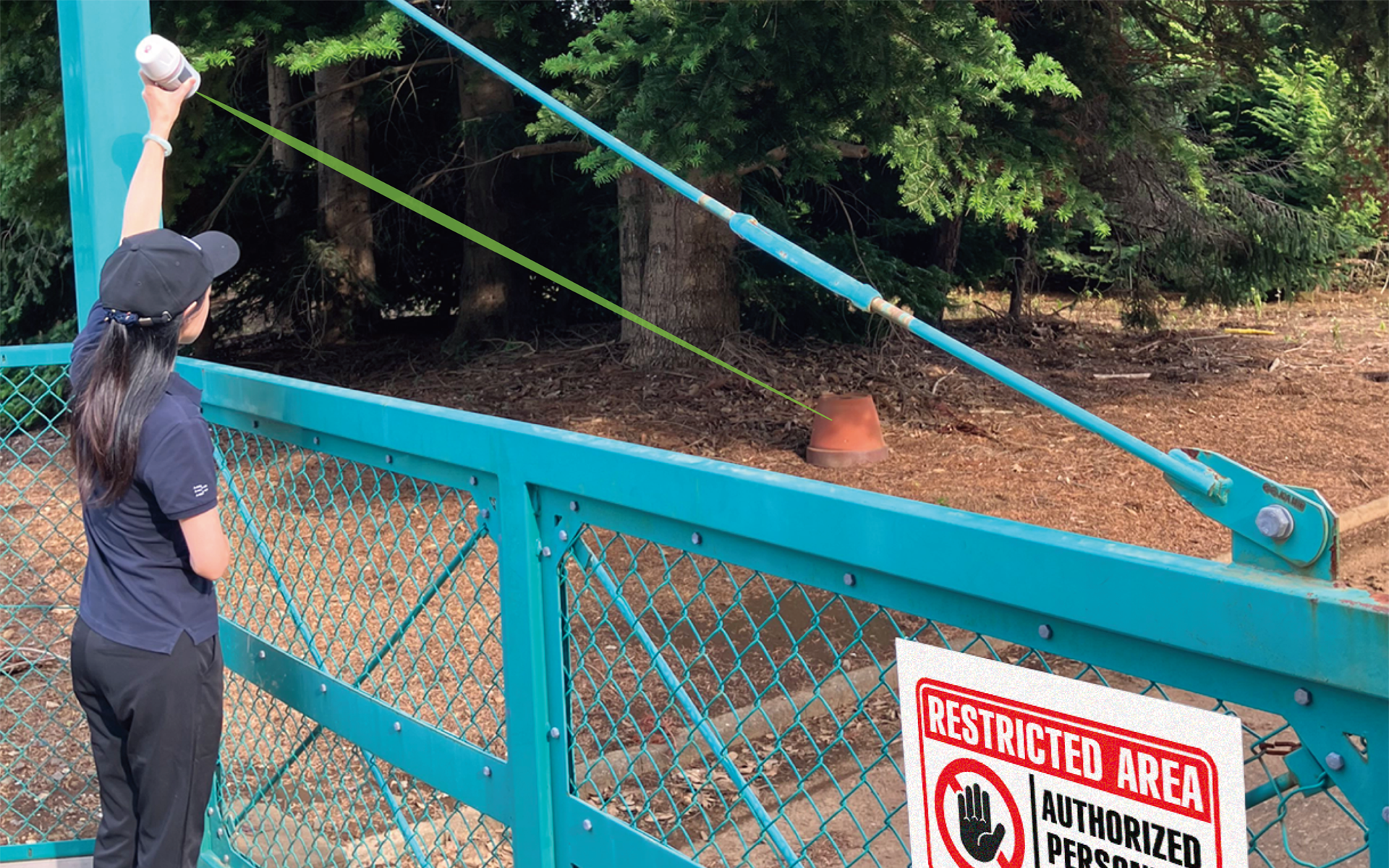
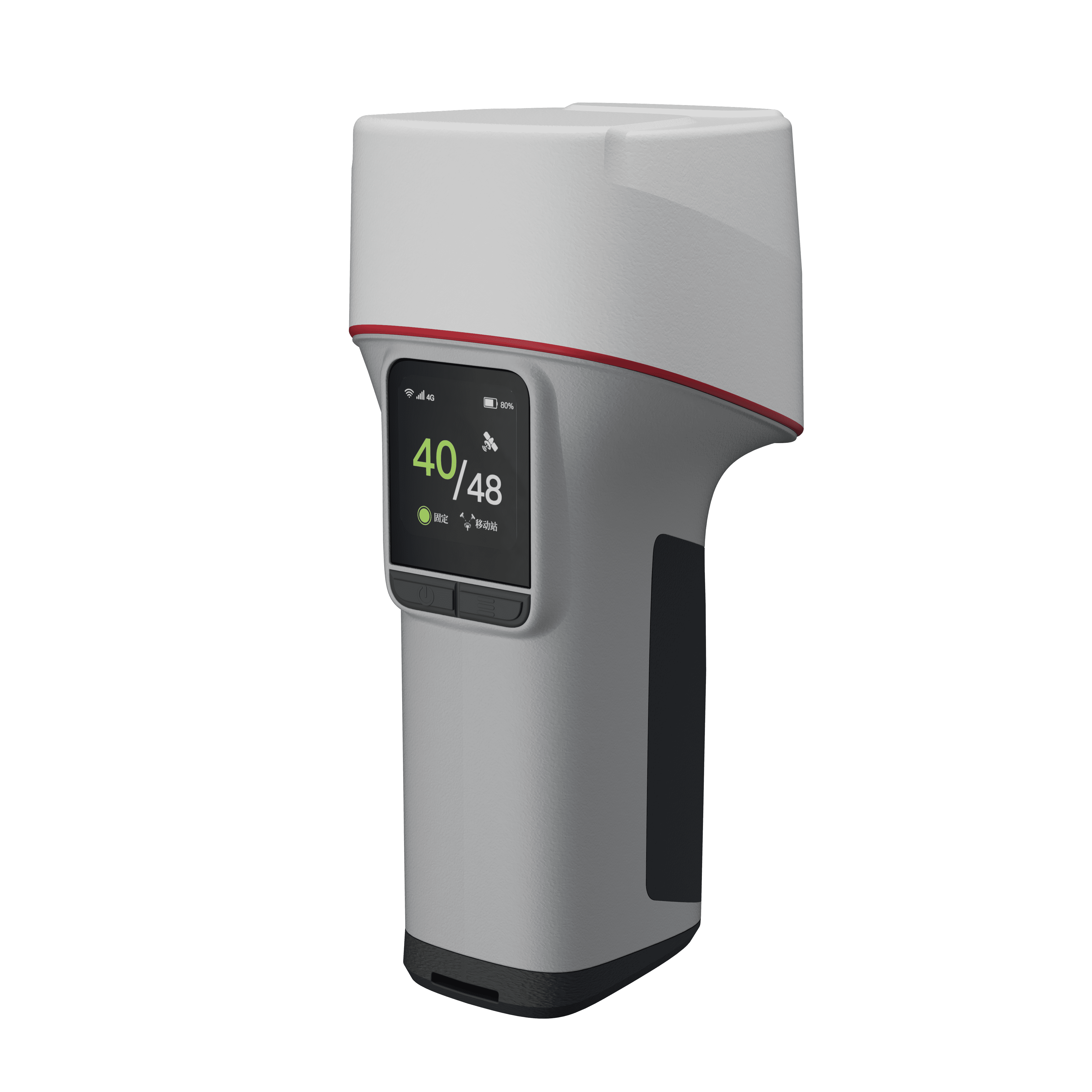
LS600 レーザースキャナーは、次世代型ハンドヘルド3Dレーザースキャナーで、先進のSLAM技術、内蔵RTKモジュールによりセンチメートル級の精度を実現します。デュアル48MP広角カメラを搭載し、高精度のカラーポイントクラウドを生成。デュアル広角カメラとVSLAMが、LiDAR点群に高精細な色とテクスチャを付与。GNSS/RTK+SLAMの統合で、森林や市街地でも安定したトラッキングと高精度を実現します。
LS600 レーザースキャナーは、次世代型ハンドヘルド3Dレーザースキャナーで、先進のSLAM技術、内蔵RTKモジュールによりセンチメートル級の精度を実現します。GNSS/RTKとSLAMを融合した独自の統合測位により、従来のSLAM単体では難しかった広域環境や長距離計測でも高い位置精度と安定したトラッキングを維持します。森林や市街地、建設現場などGNSS環境が変化する現場でも安定した計測が可能です。
デュアル48MP広角カメラを搭載し、高精度のカラーポイントクラウドを生成。デュアル広角カメラとVSLAMが、LiDAR点群に高精細な色とテクスチャを付与し、現実空間を忠実に再現した高品質な3Dデータを取得できます。これにより、点群データの視認性や解析効率を大幅に向上させます。
軽量・コンパクトなハンドヘルド設計により、誰でも直感的に操作でき、短時間で広範囲の3D計測を実現。測量、建設、インフラ点検、都市モデリング、森林計測など、さまざまな分野でのデジタル化・DXを強力に支援します。さらに取得した点群データは各種ソフトウェアと連携し、現場から解析・活用までスムーズなワークフローを実現します。
The LS600 Laser Scanner is a next-generation handheld 3D laser scanner that achieves centimeter-level accuracy through advanced SLAM technology and a built-in RTK module. By integrating GNSS/RTK with SLAM, it provides a unique hybrid positioning solution that maintains high positional accuracy and stable tracking even in large-scale environments or long-distance surveys where conventional SLAM-only systems often struggle. This enables reliable measurement in complex environments such as forests, urban areas, and construction sites where GNSS conditions frequently change.
Equipped with dual 48 MP wide-angle cameras, the LS600 generates highly accurate colorized point clouds. The combination of dual wide-angle cameras and VSLAM adds high-resolution color and texture to LiDAR point clouds, enabling the creation of high-quality 3D data that faithfully reproduces real-world environments. This significantly improves the visibility and analytical efficiency of point cloud data.
With its lightweight and compact handheld design, the LS600 allows intuitive operation for users of all experience levels and enables rapid acquisition of large-scale 3D data in a short time. It strongly supports digital transformation (DX) across a wide range of applications, including surveying, construction, infrastructure inspection, urban modeling, and forest measurement. The collected point cloud data can also be seamlessly integrated with various software platforms, enabling an efficient workflow from field data capture to processing, analysis, and practical utilization.

マーキュリー・レーザーRTK
Mercury Laser RTK
マーキュリー・レーザーRTKは、RTK測位とレーザー測距を融合した次世代GNSS受信機です。従来の測量のようにポールを対象点に直接設置する必要がなく、離れた場所から安全かつ迅速に測位できるポールフリー測量を実現します。新しいK9チップアーキテクチャと高度なIMUアルゴリズムにより、傾斜補正を含む高精度RTK測位を安定して提供します。
本体には最大50mの測距が可能なグリーンレーザーと長焦点カメラを搭載。画面上で対象物を確認しながら直感的に測定できる“見たまま測れる(What You See Is What You Measure)”新しい測量スタイルを実現します。建物の角、フェンス、斜面、危険箇所など、ポールを設置しにくい場所でも効率的に座標取得が可能です。
さらにAuto-IMU機能により、動作中に自動初期化されるため面倒なキャリブレーションは不要。高解像度タッチスクリーンとショートカットボタンにより、点・線・ポリゴン測量を直感的に操作できます。測点ごとに写真と座標情報を自動記録する機能も備え、測量成果のトレーサビリティを確保します。Wi-Fi、Bluetooth、4G通信にも対応し、さまざまな現場で柔軟な運用が可能です。
The Mercury Laser RTK is a next-generation GNSS receiver that integrates RTK positioning with laser measurement technology. It enables pole-free surveying, allowing users to measure points safely and efficiently from a distance without placing a survey pole directly on the target point. Powered by the new K9 chip architecture and advanced IMU algorithms, the system delivers stable, high-precision RTK positioning with reliable tilt compensation.
The device is equipped with a green laser capable of measuring distances up to 50 meters, along with a long-focus camera. Users can visually confirm targets on the screen and measure them intuitively, enabling a new surveying style described as “What You See Is What You Measure.” This makes it possible to efficiently capture coordinates for points that are difficult or unsafe to access with a survey pole, such as building corners, fences, slopes, or hazardous areas.
Mercury Laser RTK also features Auto-IMU, which automatically initializes during motion, eliminating the need for manual calibration. The high-resolution touchscreen and dedicated shortcut buttons provide an intuitive interface for point, line, and polygon measurements. In addition, the system automatically records a photo with coordinates and annotations for each measured point, ensuring clear documentation and traceability of survey results.
With support for Wi-Fi, Bluetooth, and 4G connectivity, the Mercury Laser RTK offers flexible operation in a wide range of field environments. Combining RTK precision with laser measurement and intuitive visualization, it provides an efficient and innovative solution for modern surveying workflows.
P6Hハンドヘルド
P6H Handheld
P6Hハンドヘルドは、GNSSフルコンステレーションとマルチ周波数に対応したプロフェッショナル向けハンドヘルド端末です。SinoGNSSが独自に開発したK9高精度GNSSモジュールとアンテナを搭載し、センチメートル級のRTK精度を実現。さらに、PPP-HASやPPP-B2bによるデシメートル級の精度にも対応し、通信ネットワークが利用できない環境でも高精度を維持します。
P6Hハンドヘルドは、高精度GNSS受信機とハンドヘルド端末を一体化した設計により、現場での機動性と操作性を両立。高感度アンテナと安定した信号追尾性能により、都市部や樹林環境など衛星受信条件が厳しい場所でも安定した測位を実現します。
堅牢で軽量な筐体に、Android 11 OSと豊富な通信機能を備え、測量とGISの両ニーズに応える多用途なデバイスです。Wi-Fi、Bluetooth、4G通信などに対応し、各種クラウドサービスや業務アプリケーションとの連携も可能。インフラ管理、森林調査、資産管理、フィールドデータ収集など、幅広い分野で効率的な位置情報取得とデータ管理を支援します。
The P6H Handheld is a professional handheld device that supports full GNSS constellations and multi-frequency signals. It is equipped with the SinoGNSS K9 high-precision GNSS module and antenna, independently developed by SinoGNSS, enabling centimeter-level RTK positioning accuracy. In addition, it supports PPP-HAS and PPP-B2b, providing decimeter-level positioning accuracy even in environments where communication networks are unavailable, ensuring reliable high-precision positioning in remote or disconnected areas.
The P6H Handheld integrates a high-precision GNSS receiver and a handheld terminal into a single device, achieving both mobility and ease of operation in the field. With its high-sensitivity antenna and stable signal tracking capability, it maintains reliable positioning performance even in challenging environments such as dense urban areas or forested locations where satellite reception conditions are often limited.
Featuring a rugged yet lightweight design, the P6H runs on Android 11 OS and offers a wide range of communication options. It supports Wi-Fi, Bluetooth, and 4G connectivity, allowing seamless integration with cloud services and various field applications. Designed to meet the needs of both surveying and GIS applications, the P6H provides a versatile solution for efficient spatial data collection and management.
It is well suited for a wide range of professional uses, including infrastructure management, forestry surveys, asset management, and field data collection, helping organizations efficiently acquire accurate positioning information and manage geospatial data in diverse field environments.
共同出展社:コムナブ・テクノロジー
共同出展社:ComNav Technology
ジュピター・レーザーRTK
Jupiter Laser RTK
ジュピター・レーザーRTKは、最先端のGNSS、IMU、レーザー、デュアルカメラ技術を統合した高性能GNSS受信機です。特に、50メートルの範囲で昼間でも視認可能な緑色レーザーを搭載し、手の届きにくい場所や危険な場所でも安全かつ正確な測定を可能にします。従来のポール設置が難しい場所でも、離れた位置から効率的に座標取得ができ、測量作業の生産性を大きく向上させます。
デュアルカメラ技術によりリアルタイムの3Dガイダンスを提供し、画面上で対象物を確認しながら直感的に測定できるビジュアル測量を実現。複雑な現場環境でも迅速かつ正確な測量をサポートします。また、自動IMU機能により手動での初期化が不要となり、最大60°のチルト補正に対応。ポールを傾けた状態でも高精度なRTK測位を維持します。さらに、OLEDカラースクリーンを搭載し、衛星受信状況や電源状態などの重要な情報をリアルタイムで確認可能。視認性に優れた表示により、現場での操作性と作業効率を高めます。
ジュピター・レーザーRTKは、レーザー測距とビジュアル測量を融合した次世代RTKソリューションとして、測量・建設・インフラ分野における効率的な現場作業を支援します。
The Jupiter Laser RTK is a high-performance GNSS receiver that integrates advanced GNSS, IMU, laser, and dual-camera technologies. It is equipped with a green laser that remains visible even in daylight and can measure targets up to 50 meters away, enabling safe and accurate measurements in locations that are difficult to reach or potentially hazardous. Even in areas where placing a survey pole directly on the target point is difficult, users can efficiently capture coordinates from a distance, significantly improving the productivity of surveying operations.
With its dual-camera technology, the Jupiter Laser RTK provides real-time 3D guidance, enabling visual surveying by allowing users to confirm targets on the screen and measure them intuitively. This feature supports fast and accurate measurements even in complex field environments. In addition, the built-in Auto-IMU function eliminates the need for manual initialization and supports tilt compensation of up to 60°, maintaining high-precision RTK positioning even when the survey pole is tilted.The receiver also features an OLED color screen that displays key information such as satellite status and power conditions in real time. Its clear and easy-to-read interface improves usability and operational efficiency in the field.
By combining laser ranging with visual surveying technology, the Jupiter Laser RTK represents a next-generation RTK solution designed to enhance field productivity in surveying, construction, and infrastructure applications.
マーズ・レーザーRTK
Mars Laser RTK
マーズ・レーザーRTKは、最新のGNSS、IMU、レーザー技術を統合した革新的なGNSS受信機です。これまで手が届きにくかったり、信号が遮断されていたり、危険を伴う現場でも、Marsの背面に搭載されたミリレベルレーザー距離計により、測量や杭打ち作業をより簡単かつ安定して行うことができます。直接ポールを設置できない場所でも、離れた位置から正確に座標を取得でき、作業効率と安全性を大きく向上させます。
マーズには最新のK8プラットフォームが搭載されており、現在稼働しているすべてのGNSS衛星を1590チャンネルで追跡します。さらに、内蔵のIMUセンサーは最大60°の傾き補正に対応しており、ポールを傾けた状態でも高精度な測量結果を得ることが可能です。
またマーズは、国土地理院の性能基準に基づく検定・登録を経て、1級GNSS測量機として正式に登録された高精度GNSS受信機です。測量・建設・インフラ分野において、信頼性の高い次世代RTKソリューションとして現場作業を強力に支援します。
The Mars Laser RTK is an innovative GNSS receiver that integrates the latest GNSS, IMU, and laser technologies into a single high-performance surveying solution. Even in environments where targets are difficult to reach, signals are obstructed, or field conditions are potentially hazardous, the millimeter-level laser rangefinder mounted on the rear of the Mars enables easier and more stable surveying and stakeout operations. It allows users to accurately capture coordinates from a distance when it is difficult or unsafe to place a survey pole directly on the target point, significantly improving both efficiency and safety in the field.
The Mars is built on the latest K8 platform, capable of tracking all currently available GNSS constellations through 1,590 channels, ensuring strong satellite signal reception and reliable positioning performance in a wide range of environments. In addition, the integrated IMU sensor supports tilt compensation of up to 60°, allowing users to maintain high-precision surveying results even when the survey pole is tilted.
Mars has also been tested and registered in accordance with the performance standards of the Geospatial Information Authority of Japan (GSI) and is officially certified as a Class-1 GNSS surveying instrument. This certification ensures that the receiver meets the strict accuracy requirements for professional surveying applications.
By combining advanced GNSS positioning with laser measurement technology, the Mars Laser RTK provides a reliable next-generation RTK solution for surveying, construction, and infrastructure applications, helping professionals perform accurate and efficient field operations in even the most challenging environments.
ヴィーナス・レーザー RTK
Venus Laser RTK
ヴィーナス・レーザー RTKは、レーザーとIMUを組み合わせた革新的なGNSS受信機です。レーザー距離計により測量ポールを対象点に直接設置する必要がなく、従来の制約を超えた柔軟なGNSS測量を可能にします。手の届きにくい場所や障害物の多い環境でも、離れた位置から効率的に座標を取得でき、安全性と作業効率を大きく向上させます。
ヴィーナスの特徴は、本体下部から地面方向へレーザーを照射する独自の設計です。多くのレーザーRTKが側方レーザーを採用しているのに対し、ヴィーナスは足元方向へのレーザー測距により、手持ちのまま迅速に測点を取得することができます。これにより、測量ポールを設置しにくい場所や迅速な位置確認が求められる場面でも、直感的で効率的な測量作業を実現します。コンパクトで軽量な設計により、ハンドヘルド機としても快適に使用でき、現場での高い機動性を発揮します。測量ポールを使用したRTK測量だけでなく、手持ちによる迅速な位置取得や現地確認など、多様な現場ニーズに柔軟に対応します。
IMUは従来モードとレーザーモードの両方で最大60°の傾き補正を実現し、フリーキャリブレーションと約10秒間の初期化をサポート。さらに、SinoGNSS K8プラットフォームに統合されたVenusは、1590チャンネルのフルコンステレーションGNSSを搭載し、都市部や樹林環境など衛星受信条件が厳しい環境でも安定した高精度測位を提供します。
ヴィーナスは、国土地理院の性能基準に基づく検定・登録を経て、1級GNSS測量機として正式に登録された高精度GNSS受信機です。測量・建設・インフラ分野において、高精度かつ効率的な現場作業を支える次世代RTKソリューションです。
The Venus Laser RTK is an innovative GNSS receiver that integrates laser measurement and IMU technologies to extend the capabilities of GNSS surveying. Its built-in laser rangefinder removes the need to place a survey pole directly on the target point, enabling flexible GNSS surveying beyond conventional limitations. Even in locations that are difficult to access or obstructed, coordinates can be captured from a distance, improving both safety and productivity in field operations.
A key feature of Venus is its unique downward laser design. Unlike many laser RTK systems that use side-facing lasers, Venus emits the laser beam from the bottom of the receiver toward the ground. This design allows users to quickly measure points directly beneath the device while holding it in hand. As a result, surveyors can efficiently capture coordinates in areas where placing a pole is difficult or where quick position confirmation is required.
The compact and lightweight design also supports convenient handheld use, providing excellent mobility in the field. In addition to conventional pole-based RTK surveying, Venus can be used for quick handheld positioning and on-site verification, offering flexibility for a variety of surveying tasks.
The integrated IMU supports tilt compensation of up to 60° in both conventional and laser modes, while free calibration and a quick 10-second initialization allow users to begin measurements without complex setup. Built on the SinoGNSS K8 platform, Venus tracks full GNSS constellations across 1,590 channels, delivering reliable high-precision positioning even in challenging environments such as urban areas or forests.
Venus has been tested and registered according to the performance standards of the Geospatial Information Authority of Japan (GSI) and is officially certified as a Class-1 GNSS surveying instrument.