基本情報
出展製品・サービス
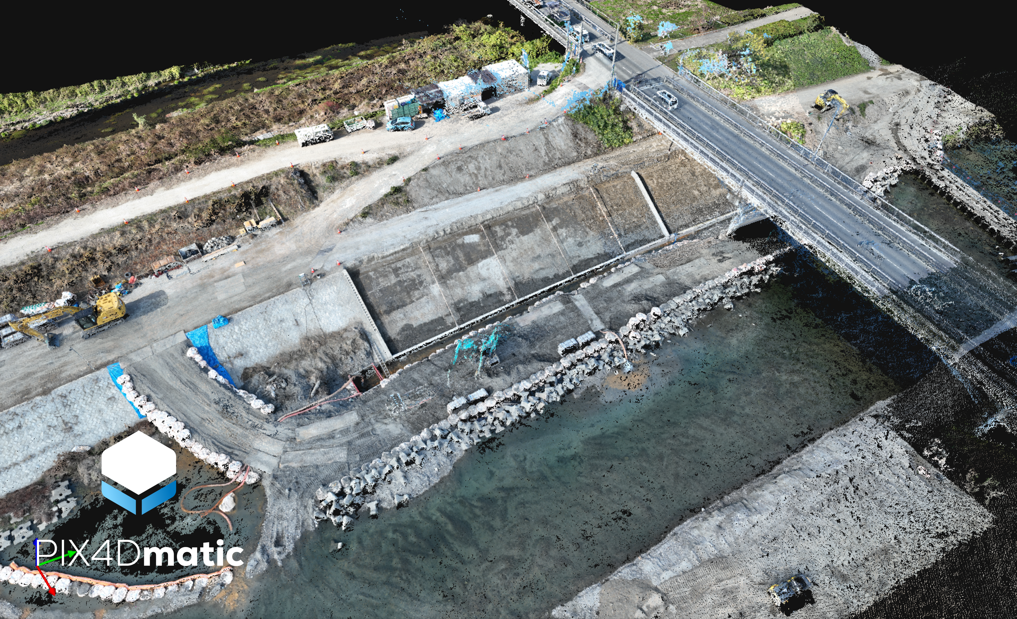
"PIX4Dmatic" スマホやドローン画像解析ソフトウェア
"PIX4Dmatic" drone and smartphone images processing software
PIX4Dmaticは、大規模データ処理に特化した次世代フォトグラメトリソフトウェアです。ドローンや航空機、スマートフォンなどで取得した大量の画像を高速かつ高精度に処理し、高密度な点群・オルソ画像・DSMなどの成果物を効率的に生成できます。最新のアルゴリズムにより、数千~数万枚規模のプロジェクトにも対応し、測量・建設・インフラ点検・鉱山・土木など幅広い分野で活用されています。さらに、点群の編集、地形抽出、ベクタ化、数量計算などの解析機能をソフトウェア内に統合しており、現場から設計・管理まで一貫した業務フローを実現します。高性能GPUを活用した処理最適化により、作業時間の短縮と生産性向上を支援し、迅速な意思決定を可能にします。安定した処理品質と再現性の高い成果物により、高い精度と信頼性が求められる業務にも対応可能です。また、クラウドサービスとの連携により、関係者間でのデータ共有や遠隔確認もスムーズに行えます。
PIX4Dmatic is a next-generation photogrammetry software designed for efficient processing of large-scale datasets. It enables users to rapidly transform large volumes of images captured by drones, aircraft, or smartphones into high-density point clouds, orthomosaics, and digital surface models with high accuracy. Powered by advanced algorithms, the software supports projects involving thousands to tens of thousands of images, making it suitable for surveying, construction, infrastructure inspection, mining, and civil engineering applications.
PIX4Dmatic integrates essential analysis capabilities within a single environment, including point cloud editing, terrain extraction, vectorization, and volume calculations, allowing users to streamline workflows from data capture to design and asset management. Optimized GPU performance significantly reduces processing time and improves overall productivity, enabling faster decision-making on site. The software delivers consistent processing quality and reliable outputs, meeting the high standards required for professional and mission-critical projects. In addition, seamless integration with cloud services supports efficient data sharing and remote collaboration among project stakeholders.
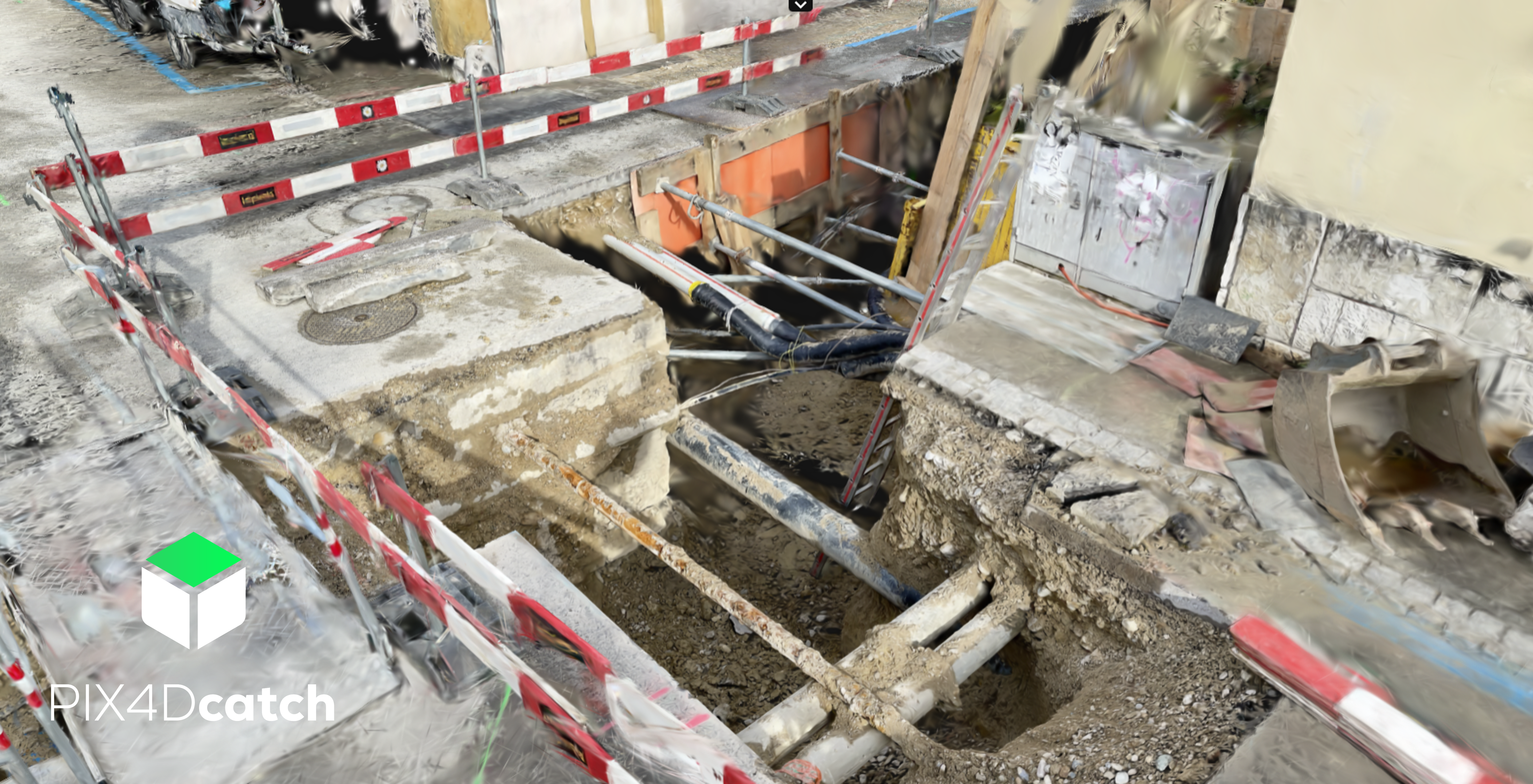
"PIX4Dcatch" ハンディ点群計測アプリ
"PIX4Dcatch" Handy pointcloud measurement app
PIX4Dcatchは、スマートフォンやタブレットを活用して高精度な3Dデータを取得できるモバイル測量アプリケーションです。専用のRTK受信機と組み合わせることで、誰でも簡単にセンチメートル級の位置精度で現場の点群データや3Dモデルを作成できます。従来は専門機器や高度な操作が必要だった空間計測を、直感的な操作とシンプルなワークフローにより効率化し、測量・建設・インフラ点検・設備管理・災害調査など幅広い分野で活用されています。取得したデータはそのままPix4Dのフォトグラメトリソフトと連携でき、点群生成や解析、共有までスムーズに実施可能です。現場での迅速なデータ取得により、作業時間の短縮や移動コストの削減を実現し、リアルタイムに近い形で状況把握や意思決定を支援します。さらに動画撮影による効率的なデータ収集にも対応しており、日常点検から大規模な現場管理まで柔軟に対応可能です。
PIX4Dcatch is a mobile data capture application that enables users to collect high-precision 3D data using smartphones or tablets. When combined with a dedicated RTK receiver, it allows anyone to generate point clouds and 3D models on site with centimeter-level positioning accuracy. Tasks that traditionally required specialized surveying equipment and advanced technical skills can now be performed more efficiently through an intuitive interface and streamlined workflow.
PIX4Dcatch is widely used across various industries, including surveying, construction, infrastructure inspection, facility management, and disaster assessment. Captured data can be seamlessly transferred to Pix4D photogrammetry software for further processing, analysis, and sharing. By enabling rapid on-site data acquisition, the solution helps reduce fieldwork time and travel costs while supporting faster situational awareness and decision-making. In addition, the application supports efficient video-based data capture, making it suitable for both routine inspections and large-scale site documentation projects.
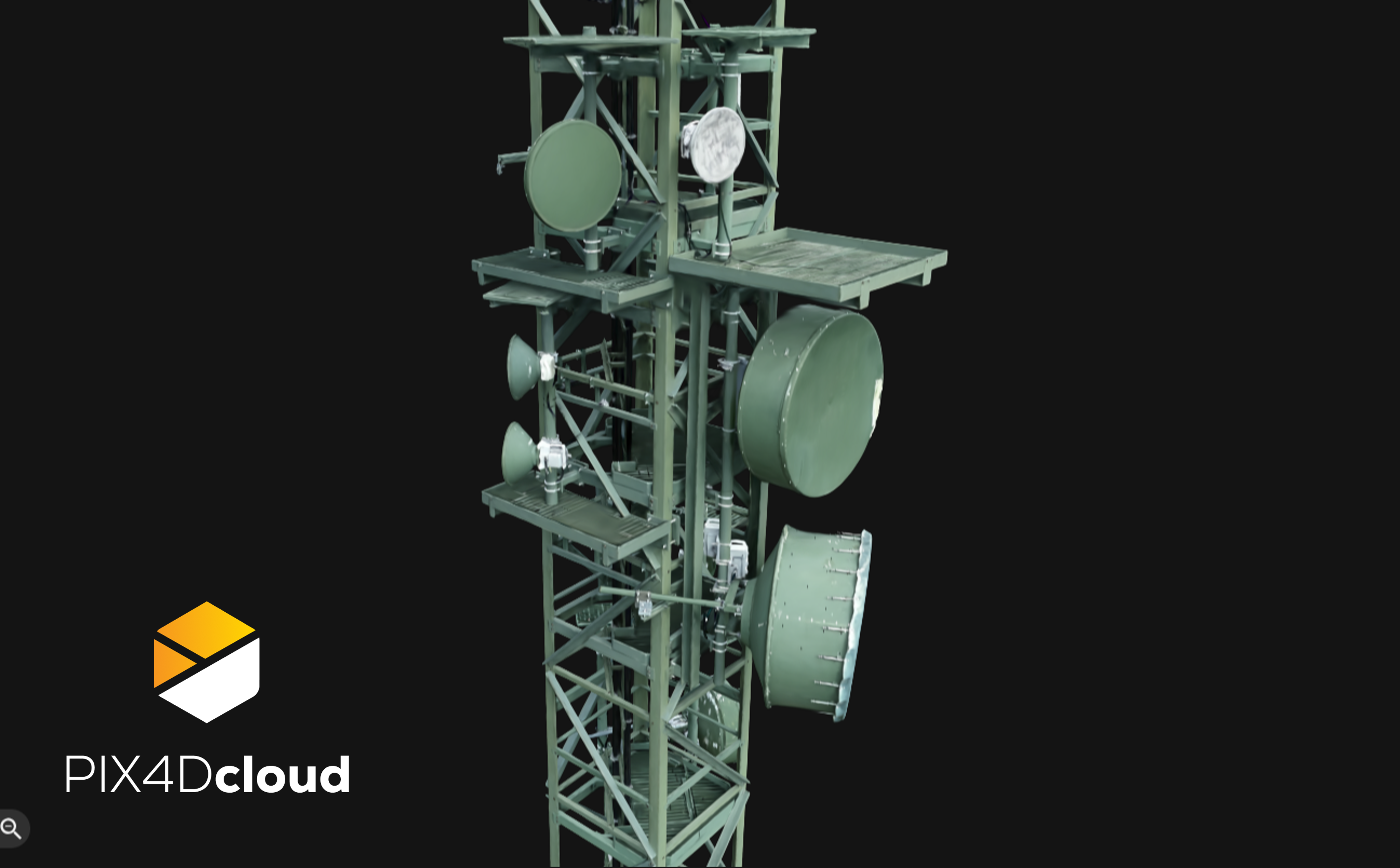
"PIX4Dcloud" 画像自動処理クラウドプラットフォーム
"PIX4Dcloud" automatic images processing on the cloud
PIX4Dcloudは、写真測量データや3Dモデルをオンライン上で処理・可視化・共有できるクラウドプラットフォームです。ドローンやスマートフォンで取得した画像データをアップロードするだけで、自動的にオルソモザイクや点群、3Dメッシュなどの成果物を生成し、ブラウザ上で直感的に確認できます。専用ソフトのインストールが不要なため、現場担当者や管理者、発注者など関係者が場所を問わず同じデータを共有でき、合意形成や業務効率の向上を支援します。
また、距離・面積・体積の計測や注釈機能を活用することで、現場の状況把握や進捗管理、報告業務をスムーズに行うことが可能です。高いセキュリティ基準のクラウド環境により、大規模プロジェクトでも安心してデータを管理できます。さらに、現場で取得したデータを迅速にクラウド上で処理できるため、意思決定のスピード向上や移動コストの削減にも貢献します。インフラ点検、建設、測量、災害対応など幅広い分野で活用され、現場とオフィスをつなぐ新しい業務スタイルを実現します。
PIX4Dcloud is an online platform that enables users to process, visualize, and share photogrammetry data and 3D models directly in the cloud. By simply uploading images captured with drones or smartphones, users can automatically generate deliverables such as orthomosaics, point clouds, and textured 3D meshes, which can be viewed and analyzed through a web browser without the need for dedicated software installation. This allows project stakeholders — including field teams, managers, and clients — to access and review the same up-to-date data anytime and from anywhere, improving collaboration and decision-making efficiency.
The platform also provides measurement and annotation tools for distance, area, and volume calculations, supporting progress tracking, reporting, and site verification tasks. Built on secure cloud infrastructure, PIX4Dcloud enables reliable data management for projects of all sizes. Rapid cloud processing helps reduce fieldwork time, travel costs, and project turnaround, making it an effective solution for infrastructure inspection, construction monitoring, surveying, mining, and disaster response workflows.
共同出展社:エムリッド
共同出展社:Emlid
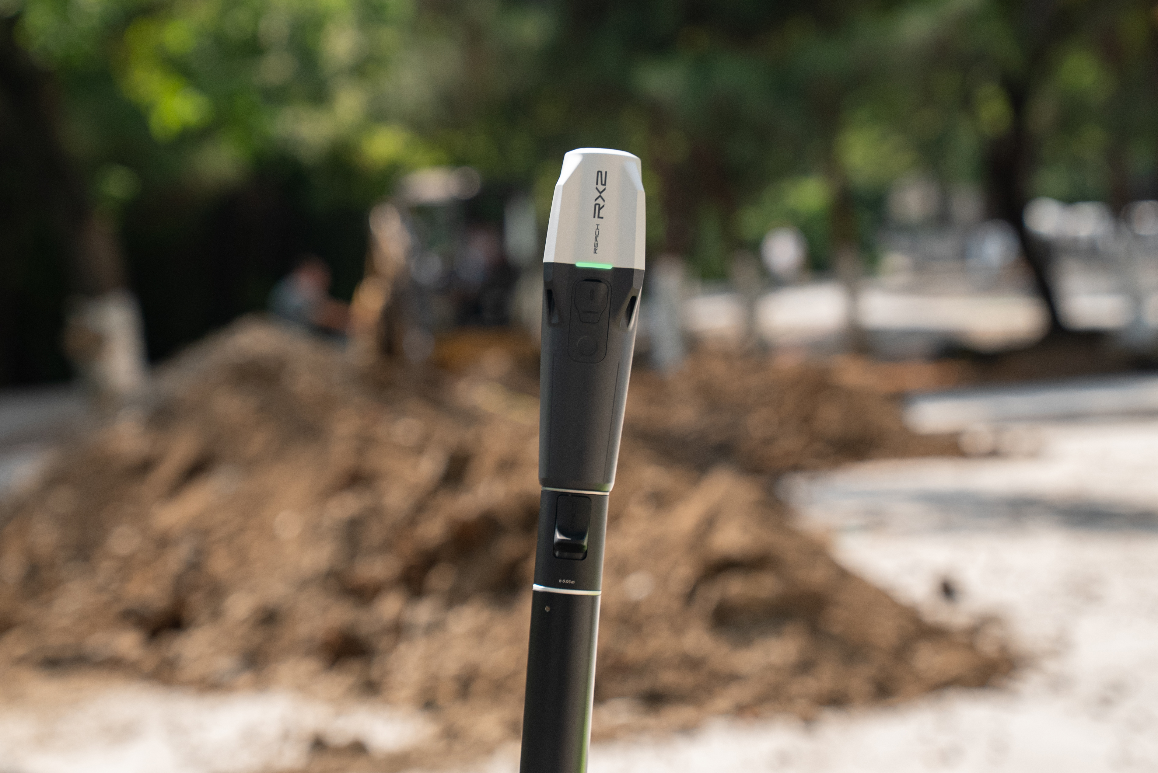
"Reach RX2" 小型軽量 × 1級精度相当 IMUチルトGNSS
"Reach RX2" Compact, Lightweight GNSS Receiver with Survey-Grade IMU Tilt Accuracy
RX2は、小型軽量設計と高精度測位性能を両立したGNSS受信機です。IMUチルト補正機能を搭載しており、ポールを傾けた状態でも迅速かつ正確な測位が可能なため、現場での作業効率を大幅に向上させます。コンパクトで持ち運びやすく、長時間の測量作業にも適しており、建設・土木・インフラ点検・設備管理など幅広い用途で活用されています。
iOSおよびAndroidのスマートフォンやタブレットと連携して使用でき、現場で取得した測位データをその場で確認・共有することが可能です。直感的な操作性により、経験の浅いユーザーでも短期間で運用を開始でき、日常点検から詳細測量まで柔軟に対応します。さらに、耐久性と信頼性を兼ね備えた設計により、厳しい屋外環境でも安定したパフォーマンスを発揮し、現場業務の効率化と生産性向上を支援します。
RX2 is a compact and lightweight GNSS receiver designed to deliver high-precision positioning performance in demanding field environments. Equipped with IMU tilt compensation, it enables fast and accurate measurements even when the survey pole is tilted, significantly improving productivity and workflow efficiency on site. Its portable design makes it ideal for long hours of fieldwork and suitable for a wide range of applications, including construction, civil engineering, infrastructure inspection, and asset management.
RX2 can be seamlessly used with iOS and Android smartphones or tablets, allowing users to capture, review, and share positioning data directly in the field. The intuitive user experience enables even less experienced users to start operations quickly, supporting tasks from routine inspections to detailed surveying. Built with durability and reliability in mind, RX2 ensures stable performance in challenging outdoor conditions, helping organizations enhance operational efficiency and make faster, data-driven decisions.
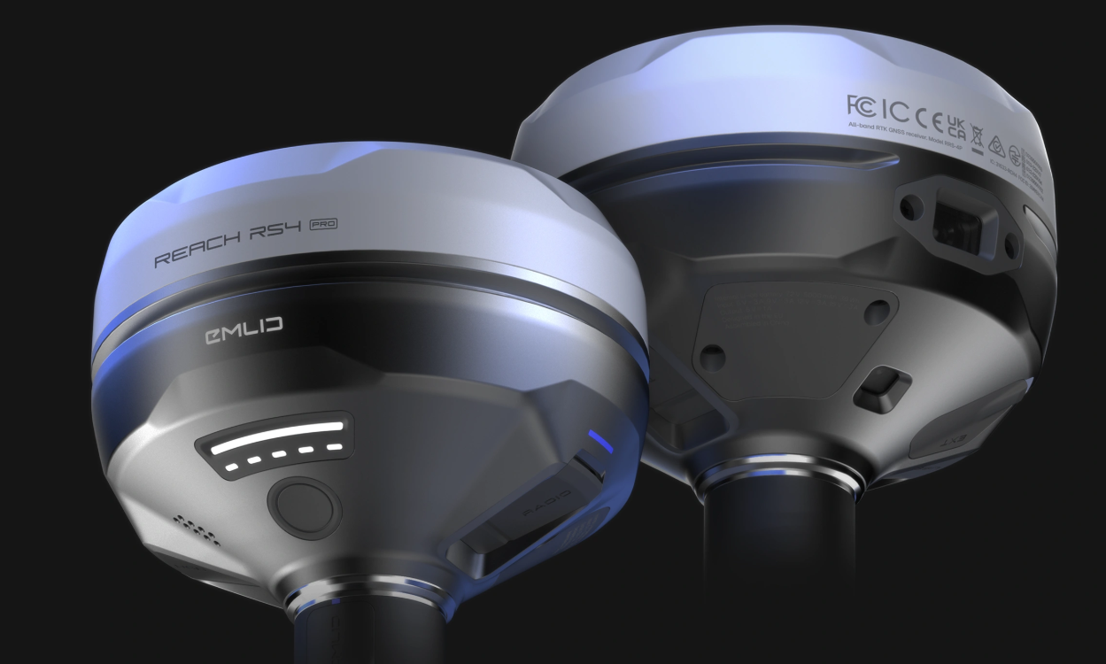
"Reach RS4 Pro" カメラ搭載 ハイエンドオールインワンGNSS
"Reach RS4 Pro" High-End All-in-One GNSS Receiver with Integrated Camera
RS4 Proは、測位と現場記録を一体化したハイエンドオールインワンGNSS受信機です。高精度なGNSS測位性能に加え、内蔵カメラ機能を活用することで、測点位置の写真記録や現場状況の可視化を同時に行うことができます。これにより、測量作業の効率化だけでなく、点検・維持管理・施工記録などの業務品質向上にも貢献します。
IMUチルト補正機能により、ポールを傾けた状態でも迅速かつ正確な測位が可能で、現場での作業時間短縮と生産性向上を実現します。また、iOSおよびAndroid端末と連携して使用でき、取得した測位データや画像情報をその場で確認・共有することが可能です。堅牢性と信頼性を兼ね備えた設計により、建設・土木・インフラ点検など多様な現場環境で安定したパフォーマンスを発揮し、現場からオフィスまで一貫したデータ活用を支援します。
RS4 Pro is a high-end all-in-one GNSS receiver that integrates precise positioning with on-site visual documentation. In addition to delivering reliable GNSS accuracy, the built-in camera enables users to capture georeferenced photos and visualize site conditions simultaneously, improving both field productivity and the quality of inspection, maintenance, and construction records.
With IMU tilt compensation, accurate measurements can be performed quickly even when the survey pole is tilted, helping reduce fieldwork time and enhance overall efficiency. RS4 Pro works seamlessly with iOS and Android smartphones or tablets, allowing positioning data and visual records to be reviewed and shared directly on site. Designed for durability and professional use, it provides stable performance across diverse environments such as construction, civil engineering, and infrastructure inspection, supporting a continuous digital workflow from field data capture to office-based analysis and reporting.
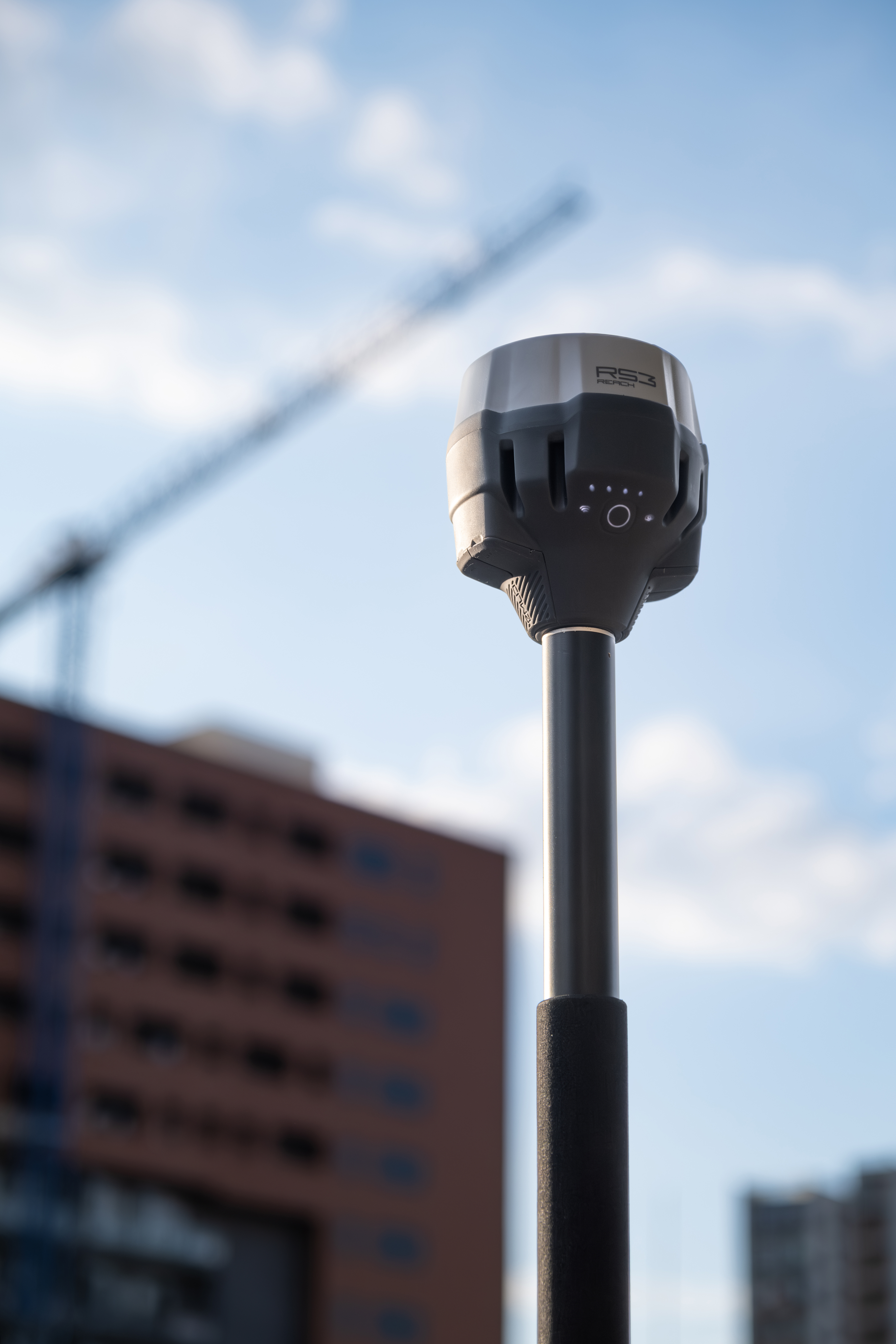
"Reach RS3" ベストバリュー × 1級登録申請中 IMUチルトGNSS
"Reach RS3" Best-Value GNSS Receiver with IMU Tilt
RS3は、高精度測位と優れたコストパフォーマンスを両立したIMUチルト搭載GNSS受信機です。ポールを傾けた状態でも迅速かつ正確な測位が可能なため、現場での作業効率を大幅に向上させます。軽量かつ扱いやすい設計により、日常的な測量作業からインフラ点検、施工管理まで幅広い用途で活用できます。
iOSおよびAndroidのスマートフォンやタブレットと連携して使用でき、取得した測位データをその場で確認・共有することが可能です。直感的な操作性により、経験の浅いユーザーでも短期間で運用を開始でき、測量業務の省力化と生産性向上に貢献します。さらに、安定した測位性能と信頼性の高い設計により、屋外の厳しい環境下でも安心して使用でき、現場からオフィスまで一貫したデータ活用を支援します。
RS3 is an IMU-enabled GNSS receiver that delivers high-precision positioning with excellent value for performance. Its tilt compensation capability allows users to perform fast and accurate measurements even when the survey pole is tilted, significantly improving field productivity and workflow efficiency. The lightweight and user-friendly design makes it suitable for a wide range of applications, from routine surveying tasks to infrastructure inspection and construction site management.
RS3 can be seamlessly used with iOS and Android smartphones or tablets, enabling positioning data to be reviewed and shared directly on site. The intuitive operation allows even less experienced users to quickly adopt the system, helping reduce manual effort and enhance overall productivity. Built for reliability and consistent performance, RS3 operates confidently in demanding outdoor environments and supports a continuous digital workflow from field data collection to office-based analysis.