基本情報
出展製品・サービス
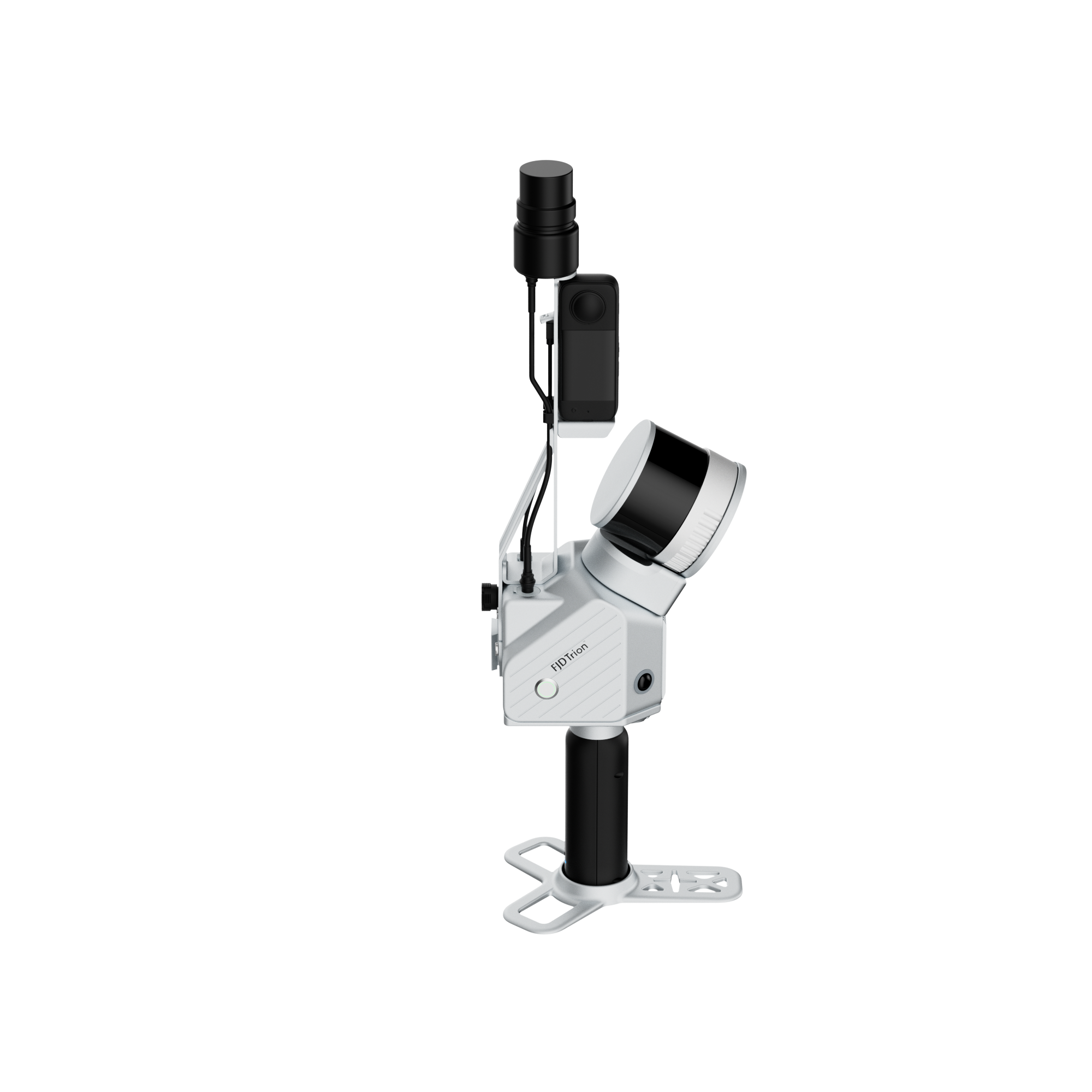
FJD Trion V4e LiDAR
FJD Trion V4e LiDAR
FJD Trion V4e LiDARは、屋内計測のために設計された次世代インドアスキャナーです。
約890gの軽量設計と60秒以内の高速起動により、現場ですぐに計測を開始。誰でも簡単に高精度な3Dデータを取得できます。
【効率的な運用】
最大5時間以上の連続稼働と約3時間の急速充電に対応。
長時間の現場作業でもバッテリーを気にせず、安定した計測作業を行えます。
【リアルタイムかつ高精度】
ライブプレビュー機能により、計測状況をその場で確認でき、取りこぼしを防止。
毎秒154,600点の高密度点群取得により、リアルタイム相対精度1cm、後処理後の絶対精度3cmを実現します。
最大50mの計測範囲に対応し、狭小空間から広い屋内施設まで、効率的で高精度な3D計測が可能です。
【多様な出力と安全性】
一度のスキャンで、BIMデータ、メッシュ、3DGSなど多様な成果物を生成。
再スキャンの手間を削減し、現場作業の効率を大幅に向上させます。
クラス1アイセーフレーザーを搭載し、人がいる環境でも安心して使用可能。
安全性と効率性を兼ね備えた屋内3D計測を実現します。
FJD Trion V4e LiDARは、迅速・高精度・シンプルな操作性を兼ね備えた次世代インドアスキャナーです。
効率的な屋内計測を求めるチームに最適なソリューションです。
Designed for the demands of modern indoor reality capture, the FJD Trion V4e LiDAR combines professional-grade precision with unmatched portability. Weighing just ~890g, this "grab-and-go" powerhouse is ready to scan in under 60 seconds, offering a plug-and-play experience that simplifies complex workflows.
Efficiency Without Compromise
Say goodbye to downtime. The V4e offers over 5 hours of continuous operation with a fast ~3-hour recharge, ensuring you can power through extensive walkthroughs without battery anxiety. Its intuitive design allows users of any skill level to capture high-quality data immediately.
Real-Time Precision
Why guess when you can know? The V4e features live preview capabilities, instantly transforming physical spaces into digital twins. This visual feedback ensures full coverage on the first pass, eliminating missed spots. Capturing an impressive 154,600 points per second, the scanner delivers dense, detailed point clouds with 1 cm relative accuracy (real-time) and 3 cm absolute accuracy (post-processed). With a range of up to 50 meters, it effortlessly handles everything from cramped rooms to larger interiors.
Versatile & Safe
One scan is all you need to generate a multitude of deliverables, including BIM-ready files, meshes, and 3DGS. This streamlined workflow removes the need for re-scanning, saving valuable time. Built with safety in mind, the Class 1 eye-safe 905 nm LiDAR technology makes the V4e suitable for use in public and occupied spaces without risk.
The FJD Trion V4e LiDAR is the definitive solution for teams seeking fast, accurate, and hassle-free indoor documentation.
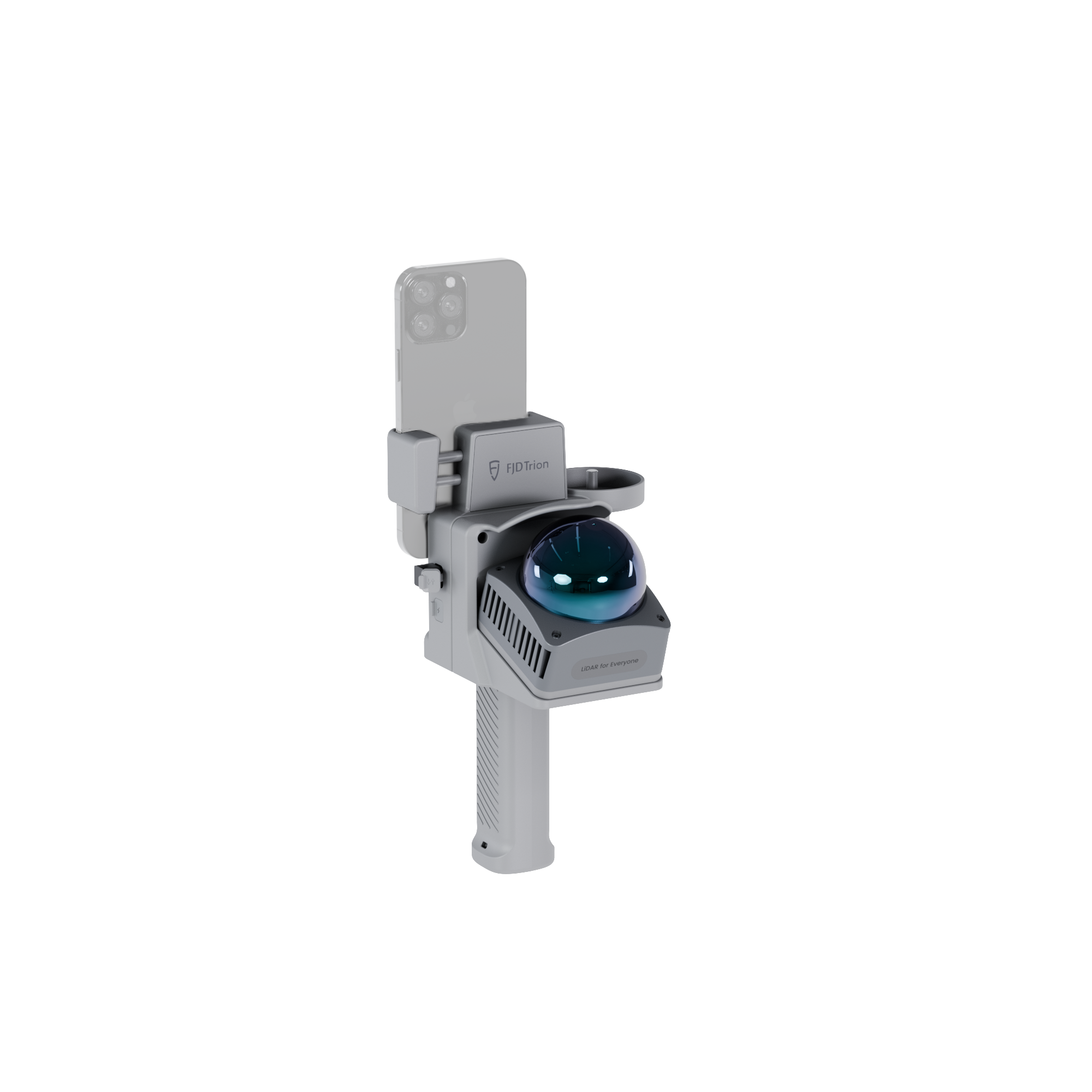
JD Trion P2 LiDAR Scanner
JD Trion P2 LiDAR Scanner
【高精度と携帯性を融合した FJD Trion P2 LiDAR スキャナー】
FJD Trion P2 LiDAR スキャナーは、産業用途に対応する高性能と優れた操作性を兼ね備えたハンドヘルド型3Dスキャナーです。
本体重量はわずか約700g。工具不要のモジュール式設計により、現場で素早く組み立ててすぐに使用できます。
ワンタッチでスキャンを開始でき、従来の煩雑なセットアップ作業を大幅に削減します。
【効率的で途切れないフィールドワーク】
360° × 59° の広視野角と最大70mの測定距離により、広範囲のデータを効率的に取得可能です。
最大4時間の連続稼働に対応し、さらにブレークポイント再開機能を搭載。
作業を中断しても同じ地点から計測を再開できるため、長時間の現場作業でも高い生産性を維持します。
【高精細な点群と高い測定精度】
視覚情報・LiDAR SLAM・GNSSを統合したハイブリッド測位により、特徴の少ない環境でも最大1cmの相対精度を実現。
独自のHyperDense+ 技術により点群密度を5〜7倍向上させ、1mm間隔の滑らかな表面表現を可能にします。
さらに、デュアル12MPカメラによるリアルタイムカラー化により、取得したデータを現場で即座に確認できます。
【多彩な成果物をワンストップで生成】
1回のスキャンから以下のような多様なデータを生成可能です。BIM対応点群データ、メッシュモデル、地理参照パノラマ、2D平面図、3D Gaussian Splatting(3DGS)
有線・無線の両方に対応した柔軟なデータ転送により、
現場計測から成果物作成までのワークフローを大幅に効率化します。
Precision Meets Portability
The FJD Trion P2 LiDAR Scanner redefines handheld scanning by merging industrial-grade performance with everyday simplicity. Weighing just 700g (core unit) and featuring a tool-free modular design, the P2 is built for true grab-and-go fieldwork. Assemble in seconds and start scanning instantly with one-touch operation—no complex setups required.
Efficient, Uninterrupted Fieldwork
Capture comprehensive data faster with a 360° × 59° FOV and a range extending up to 70 m. The P2 ensures uninterrupted productivity with up to 4 hours of battery life and a unique breakpoint resume function, allowing you to pause and continue exactly where you left off without restarting.
Uncompromising Detail & Accuracy
Trust your results with up to 1 cm relative accuracy, stabilized by visual, LiDAR SLAM, and GNSS constraints—even in feature-poor environments. The exclusive HyperDense+ technology generates point clouds 5 to 7 times denser with spacing down to 1 mm, ensuring smoother surfaces. Plus, dual 12MP cameras provide real-time colorization, so you can verify your data on the spot.
Versatile Deliverables, Instantly
Maximize the value of every scan. One capture yields multiple outputs, including BIM-ready point clouds, meshes, georeferenced panoramas, 2D floor plans, and immersive 3D Gaussian Splatting files. With flexible wired or wireless data transfer, the P2 streamlines the journey from field to finish.
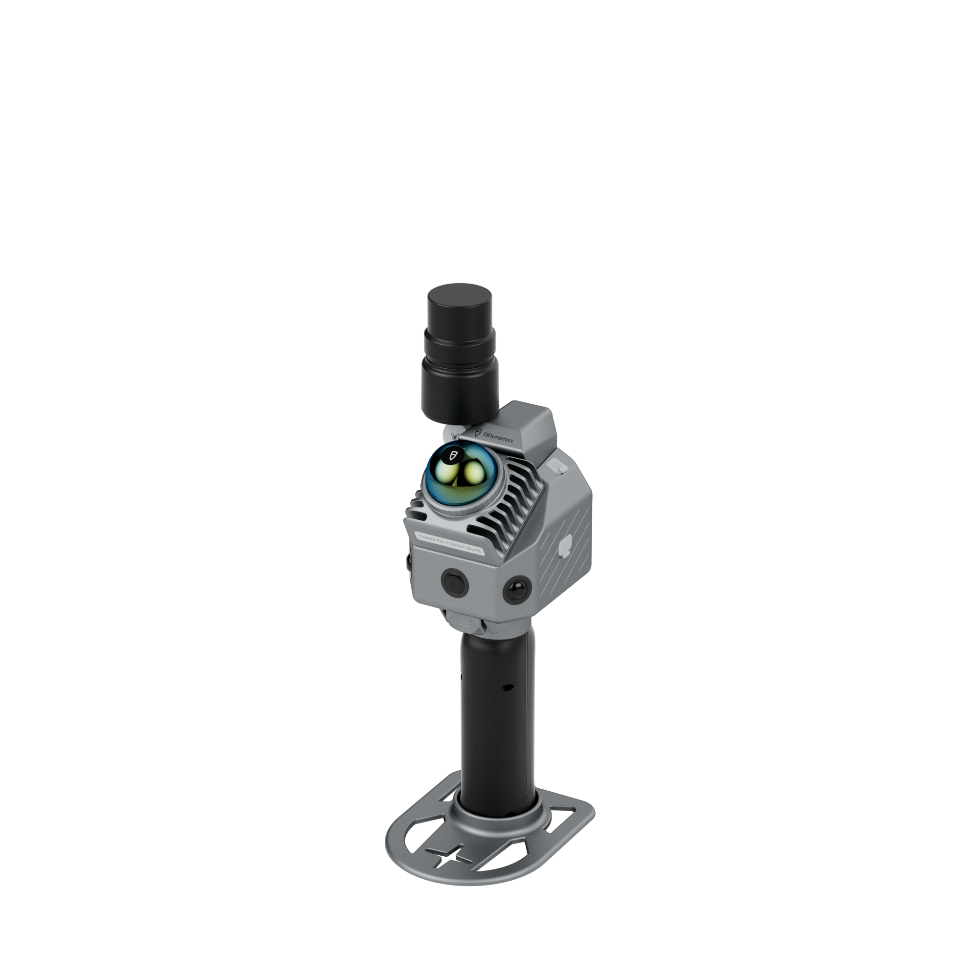
FJD Trion S2 Pro LiDAR Scanner
FJD Trion S2 Pro LiDAR Scanner
【高速測定を実現FJD Trion S2 スキャナーシリーズ】
TrionS2シリーズは大規模現場に対応するプロフェッショナルモデル。
キャプチャレートを標準モデルの2倍に強化し、最大64万ポイント/秒の高速点群取得を実現します。
高い品質を維持しながら、広範囲のエリアを効率的にカバーし、高精細なデータ取得を可能。
【広範囲をカバーする測定性能】
最大120〜300mの測定距離と360° × 270°の広視野角により、
1回のスキャンで広大なエリアを効率的に計測可能です。
死角を最小限に抑え、再スキャンの回数を削減。
大規模プロジェクトにおける作業効率の向上に貢献します。
【シームレスなワークフロー】
工具不要のモジュール設計により、数秒でセットアップが完了。
ワンタッチでスキャンを開始でき、現場での準備時間を大幅に短縮します。
さらにブレークポイント再開機能により、作業を中断しても同じ地点から計測を再開でき、長時間の作業でもスムーズに運用できます。
【高精度・高密度なデータ取得】
ビジュアルSLAM・LiDAR SLAM・GNSSを統合したハイブリッド測位により、
最大1cmの相対精度を実現。
独自のHyperDense+ 技術により点群密度を5〜7倍向上させ、
より滑らかで高精細な3Dデータを取得できます。
また、デュアル12MPカメラによるリアルタイムカラー化により、
現場で取得データをすぐに確認・検証することが可能。
【多彩な成果物に対応】
1回のスキャンから、以下のような多様な成果物を生成できます。
点群データ、メッシュモデル、2D平面図、3D Gaussian Splatting(3DGS)
さらに8000以上の座標系に対応しており、世界各国のプロジェクトでも規格に準拠したデータ作成が可能。
Built for Speed at Scale
The FJD Trion S2 Pro LiDAR Scanner is engineered for professionals who demand efficiency on large-scale sites. Doubling the capture rate of the standard S2, the S2 Pro delivers up to 640,000 points per second, ensuring faster coverage and richer detail without compromising quality.
Unmatched Range & Coverage
Spend less time repositioning. With a capture range extending from 120 m to 300 m and a 360° × 270° FOV, the S2 Pro covers vast areas in a single pass. This wide-angle capability eliminates blind spots and drastically reduces the need for repeated scans, maximizing efficiency on expansive projects.
Seamless Workflow
Efficiency starts with setup. The tool-free modular design assembles in seconds, while one-touch operation lets you start scanning immediately. Innovative features like Breakpoint Resume allow you to pause and continue exactly where you left off, ensuring uninterrupted progress even during long sessions.
Precision & Detail
Trust your data with up to 1 cm relative accuracy, supported by visual, LiDAR SLAM, and GNSS constraints—even in feature-poor environments. The exclusive HyperDense+ technology generates point clouds 5 to 7 times denser for smooth surfaces, while dual 12MP cameras provide real-time colorization for immediate on-site verification.
Versatile Deliverables
Maximize the value of every scan. One capture generates everything from BIM-ready point clouds and meshes to 2D floor plans and immersive 3D Gaussian Splatting. With support for 8,000+ local coordinate systems, the S2 Pro ensures immediate, compliant delivery for global teams.