基本情報
出展製品・サービス
ネットワーク型GNSS測位 RTK-VRS補正データサービス
Virtual Reference Station data for RTK surveying
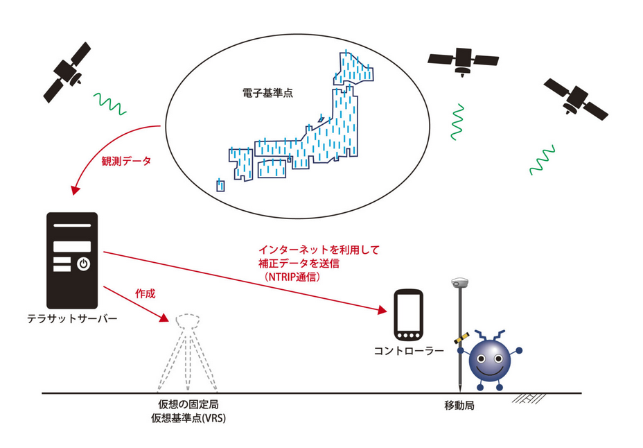
テラサット・ジャパンは、国土地理院が運営・管理するGEONET(GNSS電子基準点網)の1300点を超える全ての電子基準点を使用して、『ネットワーク型GNSS測位』のRTK補正データを提供しています。そのRTK補正データの生成システムは、25年前にドイツでVRS(Virtual Reference Station= 仮想基準点)技術を発明したTrimble Terrasat GmbH社製 の「Pivotシステム」で、BINEXデータフォーマットに完全対応し、電子基準点に設置されている受信機ブランドを問わず、すべての電子基準点からのデータを受信・処理することができます。(VRS: RTK測位の品質に影響を与える、基準局からの距離の問題を解消する技術。)
また、テラサット・ジャパンは、各電子基準点からのデータをリアルタイムに分析し、必要に応じてネットワークを最適化するPivotシステム独自のアルゴリズムを活かし、測量・建設・農業など、あらゆる用途に最高水準のGNSS補正データを提供し、高品質な測位を可能にしております。
Terasat Japan provides network-based GNSS positioning RTK correction data services using all 1,300+ electronic reference points of GEONET (GNSS Electronic Reference Point Network), operated and managed by the Geospatial Information Authority of Japan. The RTK correction data generation system is the “Pivot System” manufactured by Trimble Terrasat GmbH, the company that invented VRS (Virtual Reference Station) technology in Germany 25 years ago. It fully supports the BINEX data format and can receive and process data from all electronic reference points, regardless of the receiver brand installed at those points. (VRS: Technology that eliminates the distance-to-reference-station problem affecting RTK positioning quality.)
Furthermore, Terasat Japan utilizes the Pivot System’s unique algorithm to analyze data from each electronic reference station in real time and optimize the network as needed. This enables us to provide the highest standard of GNSS correction data for all applications, including surveying, construction, and agriculture, ensuring high-quality positioning.