基本情報
3次元情報を活用した除雪自動化システムやインフラ点検、インフラ調査を行っています。
出展製品・サービス
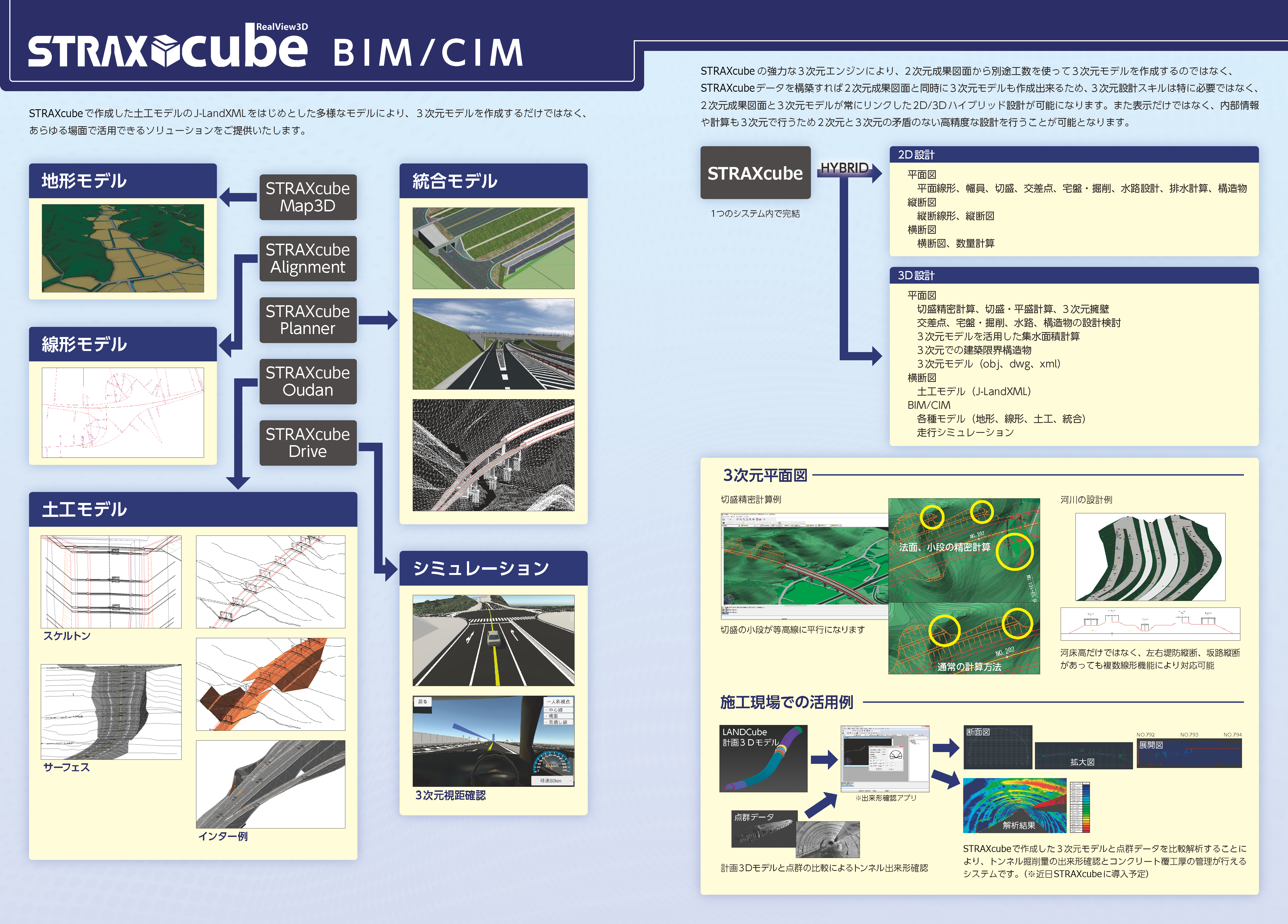
土木・道路設計3DCAD『STRAXcube』
STRAXcube - Advanced 3D CAD for Smarter Civil and Road Design
日本の道路設計に特化した純国産の土木・道路設計3DCADです。
「技術者が今まで通り2次元感覚で設計すると3次元設計ができるCAD」を設計思想とし、ど真ん中の設計作図機能、痒いところに手が届く設計検討機能、最新のBIM/CIM成果品作成機能まで搭載されています。最大の特徴は「STRAXcubeだけで詳細設計の最終成果品がハイスピードで作れる」ことです。その裏には「平面・縦断・横断のデータ連携」「本線・ランプ・側道などの複数線形計算」「縦横断設計の詳細設計対応」があります。設計現場が抱える3大課題「人材・作業効率・トレンド」のすべてをまるっと解決します。最新機能ではトンネル設計に対応しました。
STRAXcube is a purely domestic 3D CAD uniquely tailored to Japanese civil engineering and road design.
Its core philosophy: ’Create in 3D using your familiar 2D senses.’ It packs everything you need from essential design and drafting tools to highly detailed design review capabilities that hit the mark, right up to the latest BIM/CIM deliverable generation.
The biggest advantage You can rapidly produce final deliverables for detailed designs using STRAXcube alone. This is made possible by seamless data linkage of plan, profile, and cross-sections; complex multiple-alignment calculations (mainlines, ramps, frontage roads); and robust support for detailed profile and cross-section design.
It completely solves the three biggest headaches on the design front today: talent shortages, workflow efficiency, and keeping up with industry trends.
Our latest update now supports tunnel design.
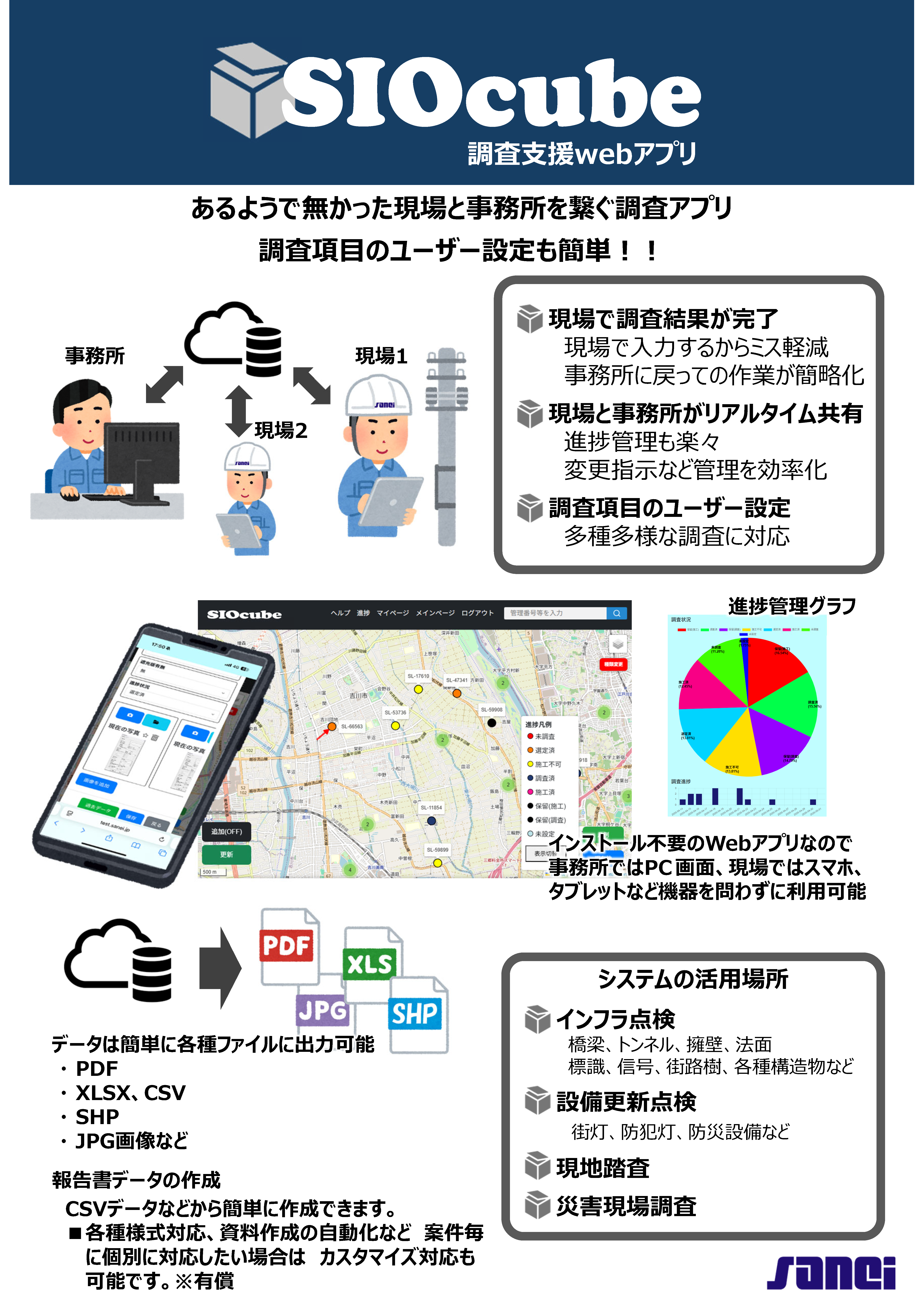
インフラ調査支援アプリ『SIOcube』
SIOcube - Infrastructure Survey Support App
あるようで無かった現場と事務所を繋ぐ調査アプリ
様々な点検調査を1つのアプリで簡単に管理できるようになります。
調査項目をユーザーで簡単に設定できるのであらゆる調査でご利用いただけます。
また複雑な調査仕様の場合でも、御社オリジナルのカスタマイズ対応も可能です。
An innovative survey app bridging the field and the office.
You can easily manage a wide variety of inspections and surveys all within a single app. Since users can easily configure their own survey items, it is adaptable for any type of investigation. Furthermore, we offer bespoke customization for your company to accommodate even the most complex survey specifications.
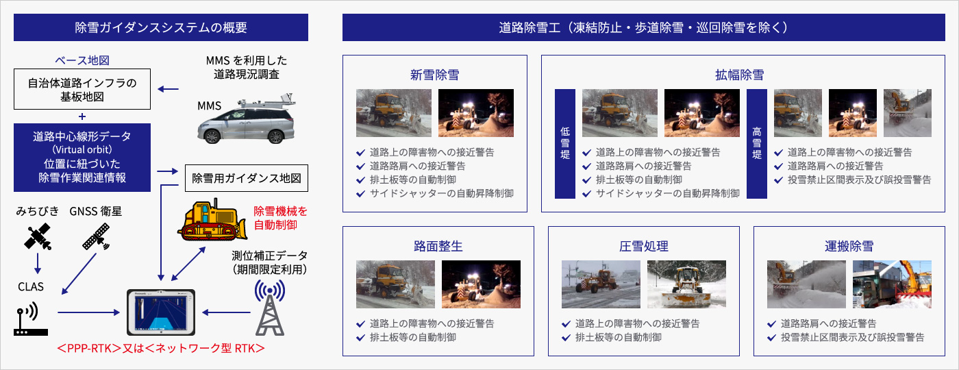
除雪ガイダンスシステム、除雪自動化システム『BLANCcube』
BLANCcube - Snow Removal Guidance System, Automated Snow Removal System
近年、豪雪地帯の自治体などでは熟練オペレータの高齢化や担い手不足等の課題に対して、将来にわたって安定的な除雪体制を確保することが喫緊の課題となっており、オペレータの浅い経験を補う支援だけではなく、1人のオペレータでも安全性を確保しながら除雪機械を自動制御できる姿を目指しています。
この問題を解決するために、MMSやドローン等の点群やカメラ情報を元に作成した高精度3D地図と、1周波RTK-GNSSなど高精度に位置測位が出来るシステムと組み合わせる事により上記課題を解決します。
更には除雪装置の自動化などに取り組み安全性の向上も目指しています。
本システムは国道や空港での除雪車に多数導入されています。
For local governments in heavy snowfall areas, the aging of skilled operators and labor shortages have made securing reliable, long-term snow removal operations an urgent priority. Our vision goes beyond simply assisting inexperienced operators; we are paving the way for a future where a single operator can safely manage automated snow clearing machinery.
We solve these industry challenges by integrating high-precision 3D maps built from MMS and drone point cloud data with pinpoint accurate positioning systems like single-frequency RTK-GNSS.
We are also taking safety to the next level by automating the snow clearing attachments. Today, our system is already trusted and utilized by snowplows on national highways and at airports.