基本情報
出展製品・サービス
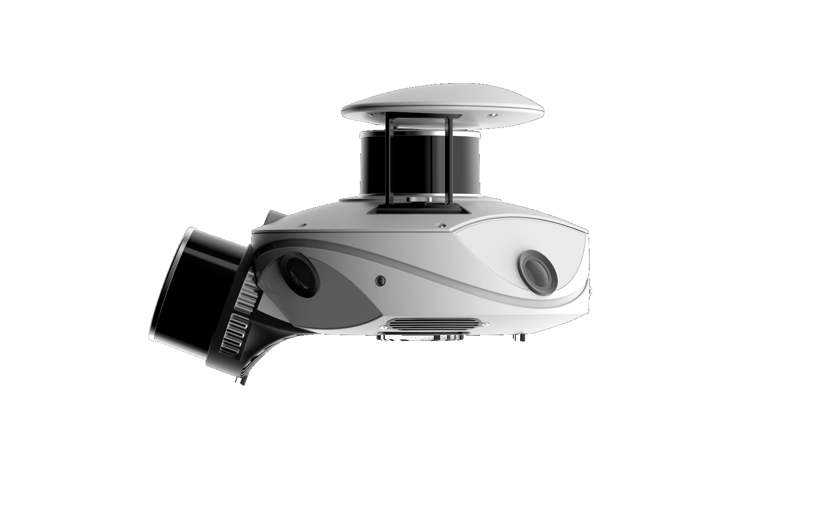
車載ベースの多目的レーザースキャナ:MS-96
MMS-based multi-purpose laser scanner: MS-96
MS-96は、柔軟なモジュール構成と軽量・コンパクトな設計を特長とする車載型レーザースキャナです。広範囲を高精度に三次元計測することが可能で、優れたIMU補正、GNSS受信機と高性能の解析ソフトを用いて最高級の点群データを提供します。
また、現場条件や運用目的に応じて機材構成を組み替えることで、様々な用途に対応可能です。バックパックやフロントパックを用いることで徒歩での詳細計測も可能となり、電動スクーターやボートなど多様なプラットフォームへの搭載にも対応しています。これにより、都市部から山間部、水辺環境まで、幅広いフィールドで柔軟に活用できます。
さらに、解析ソフトウェア PPiMMS は永続ライセンス(perpetual license)で提供され、オンプレミス環境で運用することが可能です。ユーザー自身がソフトウェアを所有し、クラウドに依存せずローカル環境でデータ処理を行えるため、セキュリティや運用面でも安心して利用できます。
道路や橋梁、トンネルなどの構造物計測から、河川・港湾周辺の地形把握まで、都市計画のシミュレーションやパイプライン点検など、多様な測量・点群活用ニーズに応えます。
MS-96 is a vehicle-mounted laser scanner featuring a flexible modular configuration and a lightweight, compact design. It enables high-precision 3D measurement over wide areas and delivers high-quality point cloud data by combining advanced IMU compensation, a GNSS receiver, and high-performance processing software.
The system can be reconfigured depending on site conditions and operational requirements, allowing it to support a wide range of applications. By using backpack or front-pack configurations, detailed data can be captured in areas where vehicles cannot access. In addition, the system can be mounted on various platforms such as electric scooters and boats, enabling flexible operation across diverse environments including urban areas, mountainous regions, and waterfront locations.
Furthermore, the analysis software PPiMMS is provided with a perpetual license and can be operated on-premise. Users fully own the software and can process data locally without relying on cloud services, ensuring greater control, security, and operational reliability.
From infrastructure measurements such as roads, bridges, and tunnels to terrain mapping around rivers and ports, the MS-96 supports a wide variety of surveying and point cloud applications, including urban planning simulations and pipeline inspections.
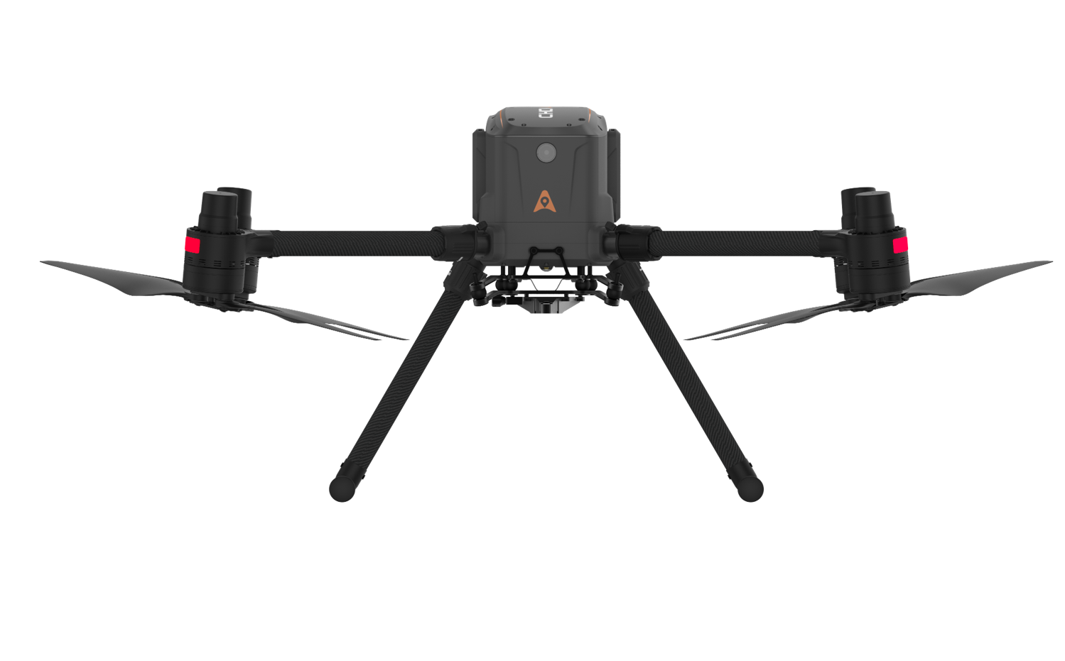
ドローン:X500
Drone:X500
X500は、公共測量およびi-Constructionに対応した産業用高性能ドローンで、測量・点検・三次元計測をはじめとする幅広い業務に対応できる空中計測プラットフォームです。最大5kgのペイロードに対応し、無積載時で最大58分、LiDAR搭載時でも長時間の連続飛行が可能です。防塵防水性能はIP55、耐風性能は最大12m/sと、屋外の厳しい環境下でも安定した運用を実現します。
デュアルGNSS、トリプルIMU、デュアル冗長フライトコントローラを備え、高い信頼性と安全性を確保しています。前方ミリ波レーダーによる障害物検知・回避機能や、ビジュアルSLAMによる高精度な位置推定により、複雑な環境でも安全な自動飛行が可能です。
また、最大3種類のペイロードを同時搭載でき、LiDARやカメラなど各種センサーに対応するとともに、オープンSDKによりサードパーティ製機器との連携にも対応します。測量、三次元都市モデリング、災害調査、インフラ点検など、空からの高精度データ取得を求める現場に最適なドローンです。
The X500 is an industrial-grade high-performance drone compatible with public surveying and i-Construction, serving as an aerial measurement platform capable of handling a wide range of tasks including surveying, inspection, and 3D measurement. It supports payloads up to 5kg, enabling continuous flight for up to 58 minutes without payload and extended flight times even when equipped with LiDAR. With IP55 dust and water resistance and wind resistance up to 12m/s, it ensures stable operation even in harsh outdoor environments.
It features dual GNSS, triple IMU, and dual redundant flight controllers, ensuring high reliability and safety. Obstacle detection and avoidance using forward-facing millimeter-wave radar, combined with high-precision position estimation via visual SLAM, enables safe autonomous flight even in complex environments.
It can simultaneously carry up to three types of payloads, supporting various sensors like LiDAR and cameras. Its open SDK enables integration with third-party devices. This drone is ideal for applications requiring high-precision aerial data acquisition, such as surveying, 3D city modeling, disaster assessment, and infrastructure inspection.
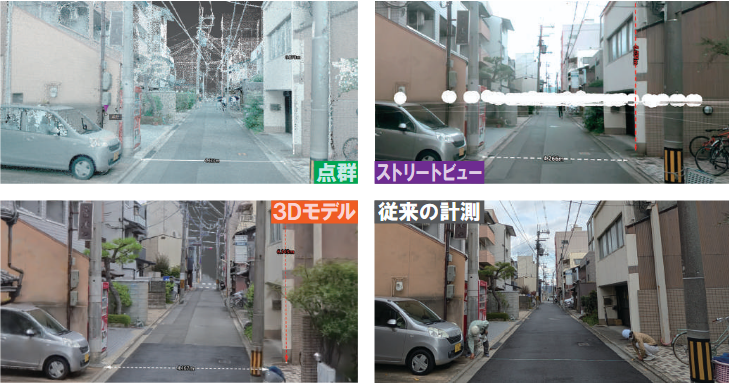
点群 と3Dモデルとストリートビューで 実現する 現場デジタル化サービス
Site Digitalization Services Using Point Clouds, 3D Models, and Street View
私たちのサービスは、専用の計測機器を用いて現場を三次元で計測し、空間をそのまま記録することから始まります。取得したデータは、点群・3Dモデル・ストリートビューなど、用途に応じた最適な形式で提供します。
作成された3Dデータにより、現地に行かなくても現場の状況を確認できるほか、建物モデルを重ねたシミュレーションや、AR・VR・ゲームコンテンツへの活用も可能です。また、実際の地図とミリ単位で重ね合わせることができ、距離・面積・体積の計測やコメント・URLリンクによる情報管理などもデータ上で行えます。これにより、現場確認や作業の効率化を大きく支援します。
当社はUAVスキャナ、車載型レーザースキャナ、ハンディレーザースキャナなど多様な計測機器を自社で保有・販売しており、屋内外の計測はもちろん、狭い場所や長距離計測など様々な環境に対応可能です。
さらに、計測からデータ解析、納品までを一貫して対応できる体制を整えており、豊富な実績と技術に基づいてお客様の課題に最適な3D計測・活用プランをご提案いたします。
Our service begins by capturing the real-world environment in three dimensions. Using specialized measurement equipment, we scan the site and obtain detailed spatial data that accurately reproduces the surrounding environment. The collected data can then be provided in the most suitable format for each purpose, including point clouds, 3D models, and street-view style visualizations.
By viewing the generated 3D data, users can check site conditions without physically visiting the location. It also enables various applications such as simulation by overlaying other building models, as well as utilization in games, AR, and VR content. Because the data can be aligned with real-world maps at millimeter-level accuracy, comparisons with actual structures are easy to perform. In addition, measurements such as distance, area, and volume can be conducted directly within the data, and information can be organized and managed by adding comments or URL links. This greatly reduces the workload associated with on-site operations.
Our company owns and supplies a wide range of measurement equipment, including UAV scanners, vehicle-mounted laser scanners, and handheld laser scanners. These systems enable measurements not only in conventional indoor and outdoor environments but also in locations that were previously difficult to measure, such as narrow spaces or long-distance sites.
Furthermore, we provide a complete workflow covering measurement, data processing, and final delivery. Based on our extensive experience and technical expertise, we propose the most suitable 3D surveying and data utilization plans tailored to each customer’s needs.