基本情報
出展製品・サービス
DPI/Dot3Dシリーズ
DPI/Dot3D Series
DPI/Dot3Dシリーズは身近なタブレットやスマートフォンで簡単に3Dスキャンできるハンディスキャナです。
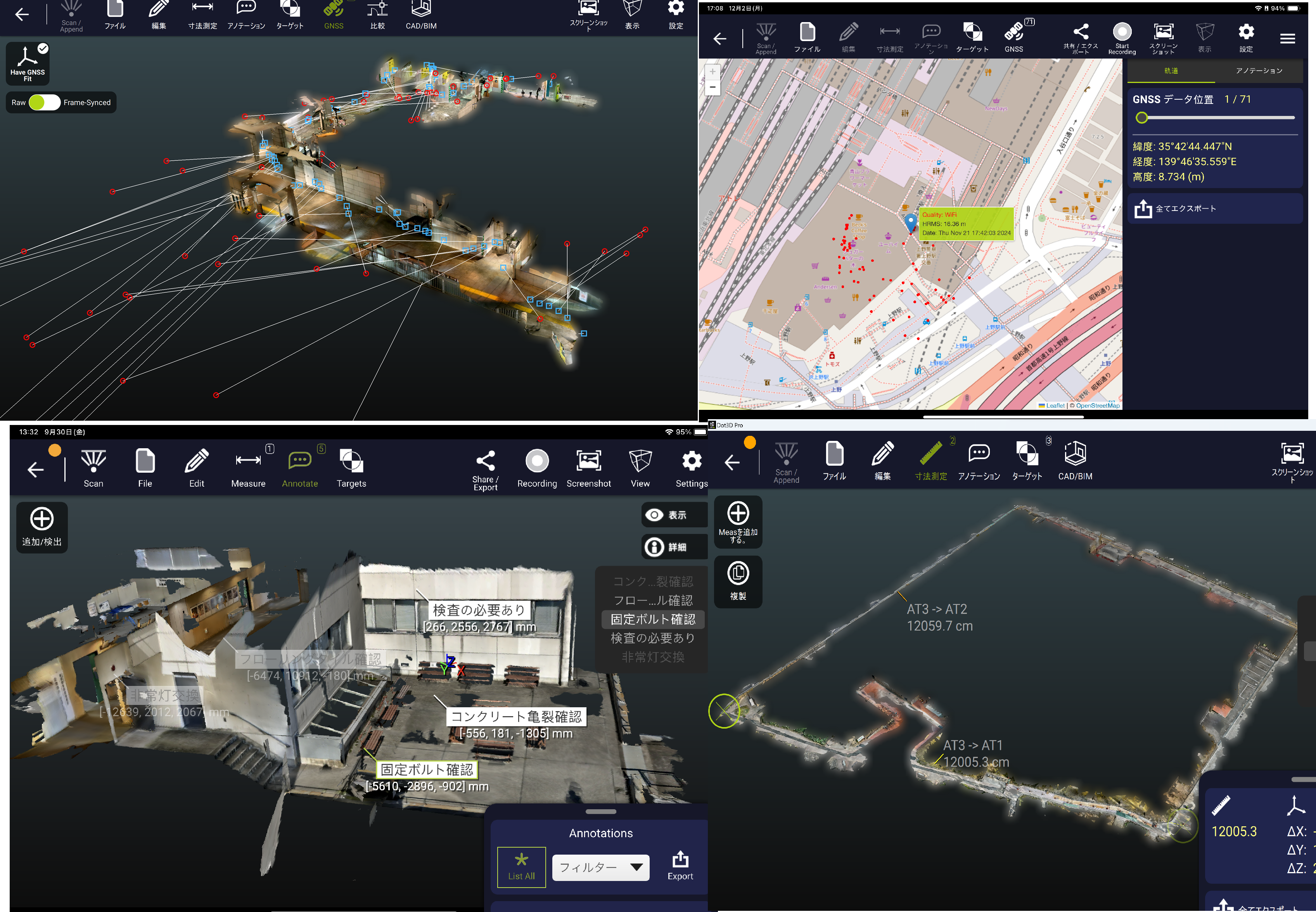
今回のCSPIでは最新バージョンを展示、内蔵GPSと連動したスキャン、点群データから簡易2D図作成、DXF出力、NeRFイメージ同時撮影等もご紹介します。
主な機能として、Dot3Dシリーズは、スキャンアプリで、iPhone ProやiPad ProのLiDARセンサーと合わせてハンディスキャナとして利用、Windows/Androidのタブレットやスマートフォンと外付けセンサーのDPI-XやIntel Realsense D455センサーと組合わせる事でスキャナとして利用するアプリです。
DPI-10シリーズは屋内向けセンサーとタブレットがセットになった一体型製品です。
DPI/Dot3Dシリーズでは簡単操作で3Dスキャンし、結果をその場で確認しスキャンエリアが不足している場合は上書き追加スキャンを行い、スキャンエリアを全て網羅する事ができます。
歩きながら移動する事で広範囲をスキャンでき、数百m単位でのスキャンを実現します。
更にスキャン中に背面カメラで写真撮影も同時にでき、スキャン後に詳細確認に利用、報告書用のJPEGファイルに出力もできます。
専用のターゲットはAR用QRコードで形状に中心点を持っており、このターゲットを設置してスキャンする事でスキャン後の形状のズレ等を補正し、閉鎖した点群データを実現、中心に測量座標を入力して点群に座標を与えて出力、ターゲットの2点間の距離を入力し、最適化する事も可能。
その他寸法測定や3Dコメント記入、各種点群ファイルへの出力も可。
The DPI/Dot3D series are handheld scanners that allow you to easily scan in 3D using a tablet or smartphone.
At CSPI, we will be exhibiting the latest version, and will also introduce scanning linked to the built-in GPS, simple 2D drawing creation from point cloud data, DXF output, simultaneous NeRF image capture, etc.
The main function of the Dot3D series is that it is a scanning application that can be used as a handheld scanner in combination with the LiDAR sensor of the iPhone Pro/Pro Max or iPad Pro, and it is also possible to use it as a handheld scanner by combining it with Windows/Android tablets and smartphones and external sensors such as DPI-X and Intel Realsense D455 sensors.
The DPI-10 series is a combined product that comes with an indoor sensor and a Microsoft SurfaceGo tablet.
The DPI/Dot3D series allows you to scan in 3D with simple operation, check the results on the spot, and if the scan area is insufficient, you can perform additional scans to overwrite the area, so you can cover the entire scan area.
By moving while walking and scanning, you can scan a wide area, and achieve scanning in units of several hundred meters.
In addition, while scanning, you can also take photos with the high-resolution camera on the back, and you can use them for detailed confirmation after scanning, or output them to JPEG files for reports.
The dedicated target (free of charge) is numbered using a QR code for AR, and has a center point in the shape of the QR code. When this target is set up and read during scanning, it is automatically recognized, and any shape discrepancies after scanning are corrected to achieve closed point cloud data. It is also possible to input survey coordinates into the center point to give the point cloud itself coordinates for output, or to input the distance between two points on the target and optimize it.
It is also possible to measure dimensions, enter 3D markup comments, and output to various point cloud files, and it is a product that can also be linked to other point cloud utilization software.

VR/AR/MR業務用3Dメタバースツール iQ3 Connect
VR/AR/MR 3D metaverse tool for business use iQ3 Connect
iQ3 Connect専用の設備や環境等利用することなく、Webブラウザを利用したクラウドサーバーベースの3D仮想空間デジタルメタバースツールです。
3D仮想空間上に点群データ、3Dモデルデータを混在・配置させ、利用ユーザーはアバターとして3D空間上を自由に動きながら検証やトレーニング等を行えます。
専用の機材や環境をお客様自ら構築する必要が無く、クラウドサーバー上に設定されたiQ3 Connectの環境にログインするだけですぐに3Dデジタルメタバース環境を構築する事ができ、大幅なコストダウンと効率よくデジタルメタバース空間を実現する事が可能です
管理者はWebブラウザからiQ3 Connectのログインし、デジタルメタバース空間に必要なデータを配置、打合せ日時の設定する事ができます。
打合せ参加者は招待されたアドレスにWebブラウザ上からログインすると即3Dデジタルメタバース空間にアクセスが可能になります。
参加者はVRゴーグルやAR端末等を用いる事で3Dデジタルメタバース空間により現実的に没入する事が可能です。
VRゴーグル、AR端末等を持たない参加者もログインし、マウスとキーボードを利用して3Dデジタルメタバース空間を自由に移動しながら3Dデータを確認する事が可能です。
3Dデジタルメタバース空間上で3Dモデルや点群データを表示させ自由に歩き回れ、空間上で寸法測定やコメント記入したり、各データの断面表示、3DCADモデルの各パーツ単位の分解や組み立てを行う事も可能です。
更に検討やトレーニングに必要な情報(動画、PDF、イメージ)等を配置したり、ホワイトボードを配置して記入も可能です。
バーチャルでのデザインレビューや動作検証、作業トレーニングなどに最適なツールです。
This is a cloud server-based 3D virtual space digital metaverse tool that uses a web browser without requiring any special equipment or environment for iQ3 Connect.
Point cloud data and 3D model data can be mixed and arranged in the 3D virtual space, and users can move freely around the 3D space as avatars to perform verification, training, etc.
There is no need for customers to build their own dedicated equipment or environment, and they can immediately build a 3D digital metaverse environment simply by logging in to the iQ3 Connect environment set up on a cloud server, making it possible to achieve a digital metaverse space with significant cost savings and high efficiency.
Managers can log in to iQ3 Connect from a web browser, place the data required for the digital metaverse space, and set the meeting date and time.
Participants in the meeting can access the 3D digital metaverse space immediately after logging in from their web browser to the address they were invited to.
Participants can use VR goggles, AR terminals, etc. to immerse themselves in the 3D digital metaverse space.
Participants without VR goggles, AR terminals, etc. can also log in and use a mouse and keyboard to move freely around the 3D digital metaverse space while checking the 3D data.
You can display 3D models and point cloud data in the 3D digital metaverse space and move around freely, measure dimensions and add comments in the space, display cross-sections of each data, and disassemble and assemble each part of the 3D CAD model.
You can also place information (videos, PDFs, images, etc.) necessary for study and training, and place and write on a whiteboard.
This is the perfect tool for virtual design reviews, motion verification, and work training.

建築系3Dモデラー SketchUp Studio
Architectural 3D modeler SketchUp Studio
SketchUpは建築・土木設計の3D化を素早く実現する3Dモデリングツールです。
従来2D CAD等による平面図設計が主流の建築・土木業界では3Dモデリング(3D モデリング)の実現には操作性・コスト等多くのハードルがありました。
このハードルをクリアできるのがSketchUpシリーズです。
もちろん、DPI/Dot3Dシリーズで取得した点群データを用いた設計も可能です(SketchUp Studioサブスクリプションで対応可能)。
それ以外の3Dスキャン、ドローン、LIDARセンサー、モバイルマッピングから点群をインポートしSketchUp上に表示する事も可能です。
ファイル形式はE57、RWP、LAZ、TZF、LAS、PLYに対応しています。
ミルトスブースではSketchUpで効率よく作業ができる3Dマウス(グラフィック操作ができるマウス)と3ボタンマウスと連動した操作をご提案します。
3D建築モデルや土木構造モデルなどを直感的に3Dデータ化することができ、3Dモデリングが初めての方でも理想の3Dモデルデータ化を実現できます。
ライセンスはサブスクリプションライセンス(年間使用料金)での購入となり、導入コストを大幅に削減しながら3Dモデリングツールを入手できます。
安価で簡単操作で3DスキャンできるDPI/Dot3Dシリーズと同じく、安価で素早く3Dモデリングが可能なSketchUpシリーズは低予算で素早い業務運用をお客様に実現します。
SketchUp is a 3D modeling tool that enables the rapid realization of 3D modeling for architectural and civil engineering design.
In the architectural and civil engineering industries, where 2D CAD and other 2D design methods have traditionally been the norm, there have been many hurdles to overcome in terms of operability and cost before 3D modeling could be realized.
The SketchUp series is the solution to these hurdles.
Of course, it is also possible to design using point cloud data acquired with the DPI/Dot3D series (this is possible with SketchUp Studio subscriptions).
It is also possible to import point clouds from other 3D scanners, drones, LIDAR sensors, and mobile mapping and display them in SketchUp.
The file formats supported are E57, RWP, LAZ, TZF, LAS, and PLY.
At the Miltos booth, we will be proposing the use of a 3D mouse (a mouse that can be used for graphic operations) and a 3-button mouse in conjunction with SketchUp to enable efficient work.
You can intuitively convert 3D architectural models, civil engineering models, etc. into 3D data, and even if you are new to 3D modeling, you can achieve ideal 3D model data conversion.
Licenses are purchased as subscription licenses (annual usage fees), so you can obtain 3D modeling tools while significantly reducing your introduction costs.
Like the DPI/Dot3D series, which can perform 3D scanning at low cost and with simple operation, the SketchUp series, which can perform 3D modeling quickly and at low cost, enables customers to achieve quick business operations at low cost.

共同出展社:モアソンジャパン
共同出展社:MORSON JAPAN
点群データを簡単・素早く・高精度に3次元モデル化 『ClassNK-PEERLESS』
ClassNK-PEERLESS
ClassNK-PEERLESSは3Dスキャナで取得した点群データから、
3DCADモデルを短時間で作成できるソフトウェアです。
一般的な点群データの読み込みに対応しており、
床や壁などの平面のほか、配管やダクト、鋼材などの要素を点群から認識しますので
現況を反映したモデルを容易に作成することが可能です。
さらに、点群データと3DCADを組み合わせた干渉チェック機能やルートチェック機能により
設備の設計や維持管理にもご活用いただけます。
また、一般的なCADデータ形式での出力にも対応しておりますので他のシステムとの連携や、
建築構造物・設備等のデジタルアーカイブ・3Dプリンティングなど
点群データを様々な形で活用することも可能となります。
BricsCAD BIM
BricsCAD BIM
共同出展社:UEL株式会社
共同出展社:UEL Corporation
POLYGONALmeister (ポリゴナルマイスター)
POLYGONALmeister (ポリゴナルマイスター)
近年、3Dプリンター、3Dスキャナ、CT装置、ドローンによる写真測量など入出力デバイスの進化により、3次元計測データを活用したお客様の業務改善活動が進みつつあります。
UELは、国立研究開発法人理化学研究所の融合的連携研究を通じて蓄積した、3次元計測機から出力されたポリゴンデータの編集処理技術を活用して、ソフトウェアパッケージ(POLYGONALmeister/出来形マイスター)の提供、APIの提供、受託開発など様々な形でお客様の業務改善活動を支援致しています。
■POLYGONALmeisterの主な機能
・LnadXML入出力
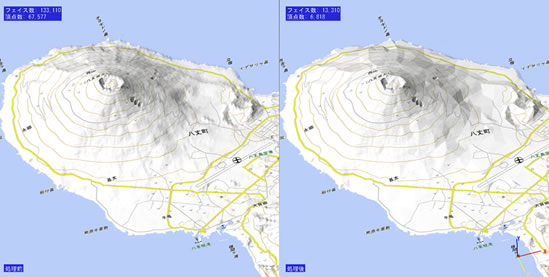
・地形メッシュ化
・土量計算
・出来形ヒートマップ
・凹凸検査
・GPS軌跡作成・編集

出来形マイスター (出来形マイスタートンネル用)
出来形マイスター (出来形マイスタートンネル用)
近年、3Dプリンター、3Dスキャナ、CT装置、ドローンによる写真測量など入出力デバイスの進化により、3次元計測データを活用したお客様の業務改善活動が進みつつあります。
UELは、国立研究開発法人理化学研究所の融合的連携研究を通じて蓄積した、3次元計測機から出力されたポリゴンデータの編集処理技術を活用して、ソフトウェアパッケージ(POLYGONALmeister/出来形マイスター)の提供、APIの提供、受託開発など様々な形でお客様の業務改善活動を支援致しています。
■出来形マイスターの主な機能
・不要点群削除機能
・点群メッシュ化機能
・厚み検査機能
- 打設前検査(当たり判定)
- 打設後検査(覆工厚判定)
- ヒートマップ表示
