基本情報
出展製品・サービス
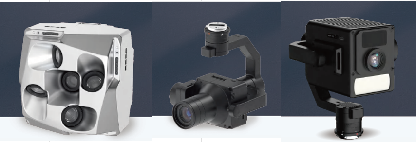
RIEBO 航空写真測量機器/データ処理システム
RIEBO Aerial photogrammetry equipments/Data Processing System
最新技術による1億画素のカメラを使用した3Dモデル作成、点検業務、AIによる腐食・ヒビ・錆などの自動検出、レポート作成と一貫した作業が可能な製品です。
データ処理はクラウド上で行うことが可能。
年間比較や履歴管理システムを実装しており、損傷の進行度を可視化し、経年変化を追跡可能となっております。
This product uses the latest technology, a 100-megapixel camera to create 3D models, performs inspection work, uses AI to automatically detect corrosion, cracks, rust, etc., and creates reports, allowing for consistent work.
Data processing can be performed on the cloud.
It also has an annual comparison and history management system, making it possible to visualize the progression of damage and track changes over time.

Flai AIフィルタリングサービス
Flai AI filtering service
日本国内の地形や地物によるAI学習を繰り返し、建設、測量ユーザの利用に対応できるサービスになります。AIフィルタリングでは、地面、植生、建物をはじめ20種類以上の地物を分類することが可能となり、レーザフィルタリングのさらなる効率化を実現しました。
The service will be able to accommodate construction and surveying users by repeatedly learning AI from the topography and features of Japan. AI filtering can now classify more than 20 types of features, including ground, vegetation, and buildings, further improving the efficiency of laser filtering.

最新計測ソリューション
Latest measurement solutions
UAV を用いた写真・レーザ計測業務、無人ボート搭載型マルチビーム測深機を活用した河川・海底地形計測をサポートいたします。
弊社所有最新機材を使用して現場計測業務を代行いたします。
要求精度に応じた機材の選定から、フライト計画~現場計測作業~データ処理までを一貫して対応できるソリューションを提供します。
We support photo and laser measurement work using UAVs, and river and seabed topography measurement using an unmanned boat-mounted multi-beam echo sounder.
We will carry out on-site measurement work on your behalf using our own state-of-the-art equipment.
We provide an integrated solution that covers everything from selecting equipment according to the required accuracy, to flight planning, on-site measurement work, and data processing.
共同出展社:テクノシステム
共同出展社:TECHNO SYSTEM
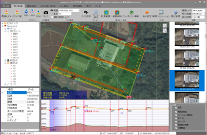
計測業務支援システムLandStation-U
Measurement Support System LandStation-U
国土地理院「作業規定の準則」準拠「第3章 UAV写真点群測量」、「第4章 UAVレーザ測量」準拠の
精度管理表作成に対応しています。空中写真測量、UAVレーザー測量の飛行計画に対応しており
「DJI Pilot2」・「Litchi」・「GS Pro(KMLインポートオプション)」など、UAVへの飛行ルート
の登録が可能です。ハンディスキャナ(LiderSLAM)に対応しています。調整点・検証点と点群LASを
取り込むことにより「LiderSLAM技術を用いた公共測量マニュアル」に準拠した帳票作成が簡単に行えます。
国土地理院「作業規定の準則」準拠「第3章 UAV写真点群測量」、「第4章 UAVレーザ測量」準拠の
精度管理表作成に対応しています。空中写真測量、UAVレーザー測量の飛行計画に対応しており
「DJI Pilot2」・「Litchi」・「GS Pro(KMLインポートオプション)」など、UAVへの飛行ルート
の登録が可能です。ハンディスキャナ(LiderSLAM)に対応しています。調整点・検証点と点群LASを
取り込むことにより「LiderSLAM技術を用いた公共測量マニュアル」に準拠した帳票作成が簡単に行えます。

共同出展社:ジツタ中国
共同出展社:JitsutaChugoku
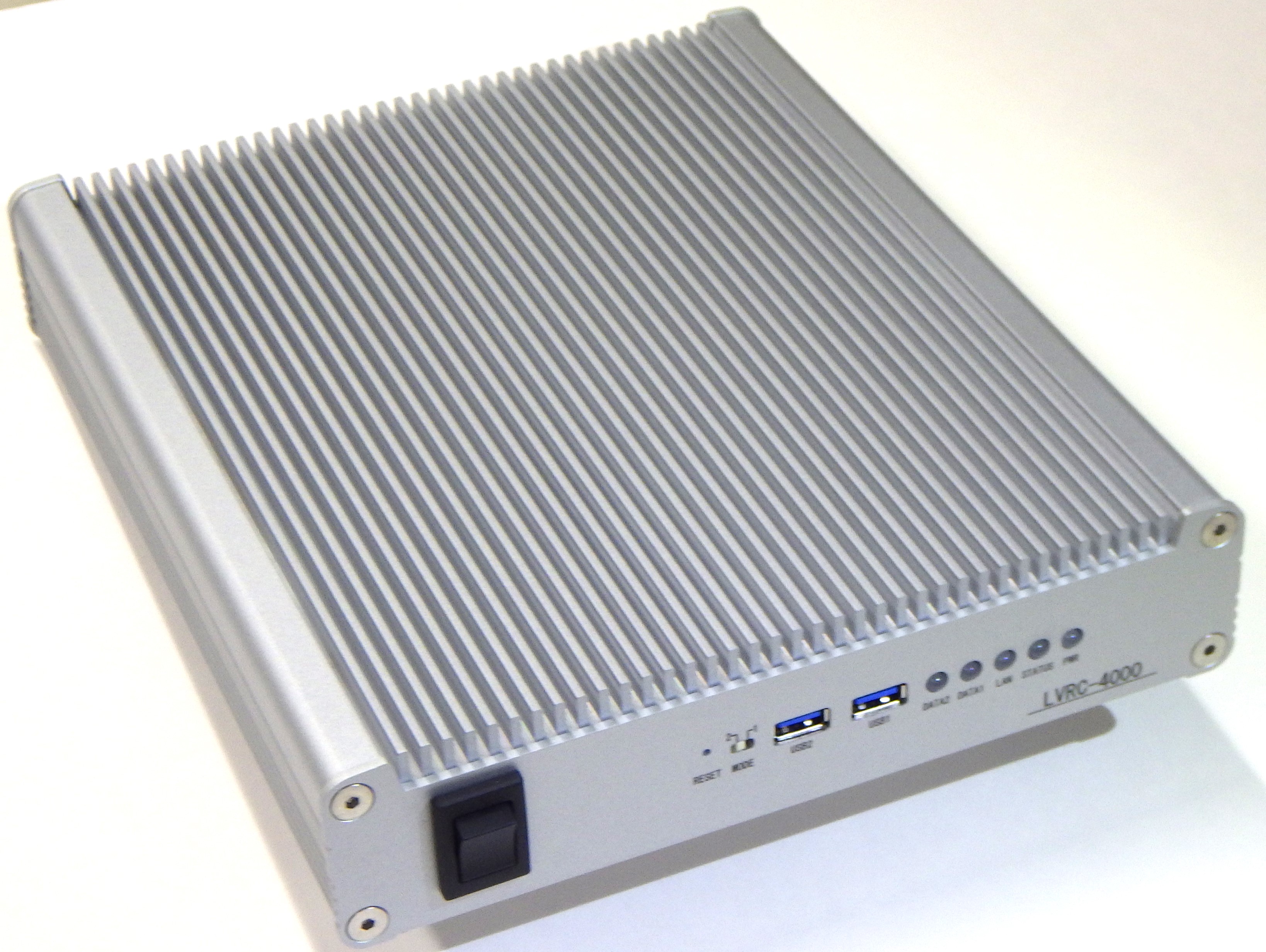
遠隔建設用低遅延エンコーダー LVRC-4000
Low latency 4ch video encoder for remote construction LVRC-4000
LVRC-4000は、2K高画質映像4本を1台のエンコーダーにて100ms以下の
低遅延で伝送できる建設機械の遠隔操縦用に開発されたシステムです。
TCP/IPのネットワーク対応をすることにより衛星回線やモバイル網など通信手段を
自由に選択ができ、幅広い解像度、フレームレート、ビットレートの入力に対応する
ことでカメラの選択を自由に行うことができます。
ハイテクインターLLC-4000と組合わせることによりパケット損失により伝送品質
が変化するネットワークに対応するためのFEC(ForwardError Correction)や誤りを検出
して誤ったデータを再送信させるARQ(Automatioc Repeat reQuest)/SRT
(Secure Reliable Transport)機能を搭載しております。
4K高画質映像を50ms以下の低遅延で送信できる機能との選択も可能で音声データの
送信機能も有しております。
まさに、重機の自動化、自律化を目指すi-Construction2.0には必須のアイテムとなります。
The LVRC-4000 can transmit four 2K high-quality videos in less than 100 ms using a single encoder.
This system was developed for remote control of construction machinery that can transmit with low latency.
By supporting TCP/IP networks, communication means such as satellite links and mobile networks
Flexible choice and support for a wide range of resolution, frame rate, and bitrate inputs
This allows you to freely choose your camera.
In combination with the high-tech Inter LLC-4000, packet loss reduces transmission quality
Detect Forward Error Correction (FEC) and errors to keep up with changing networks
ARQ (Automatioc Repeat reQuest)/SRT to retransmit erroneous data
(Secure Reliable Transport) function.
It is also possible to select a function that can transmit 4K high-quality video with a low latency of 50ms or less.
It also has a transmission function.
It is indeed an indispensable item for i-Construction 2.0, which aims to automate and autonomize heavy machinery.
