基本情報
出展製品・サービス
STRAXcube
STRAXcube
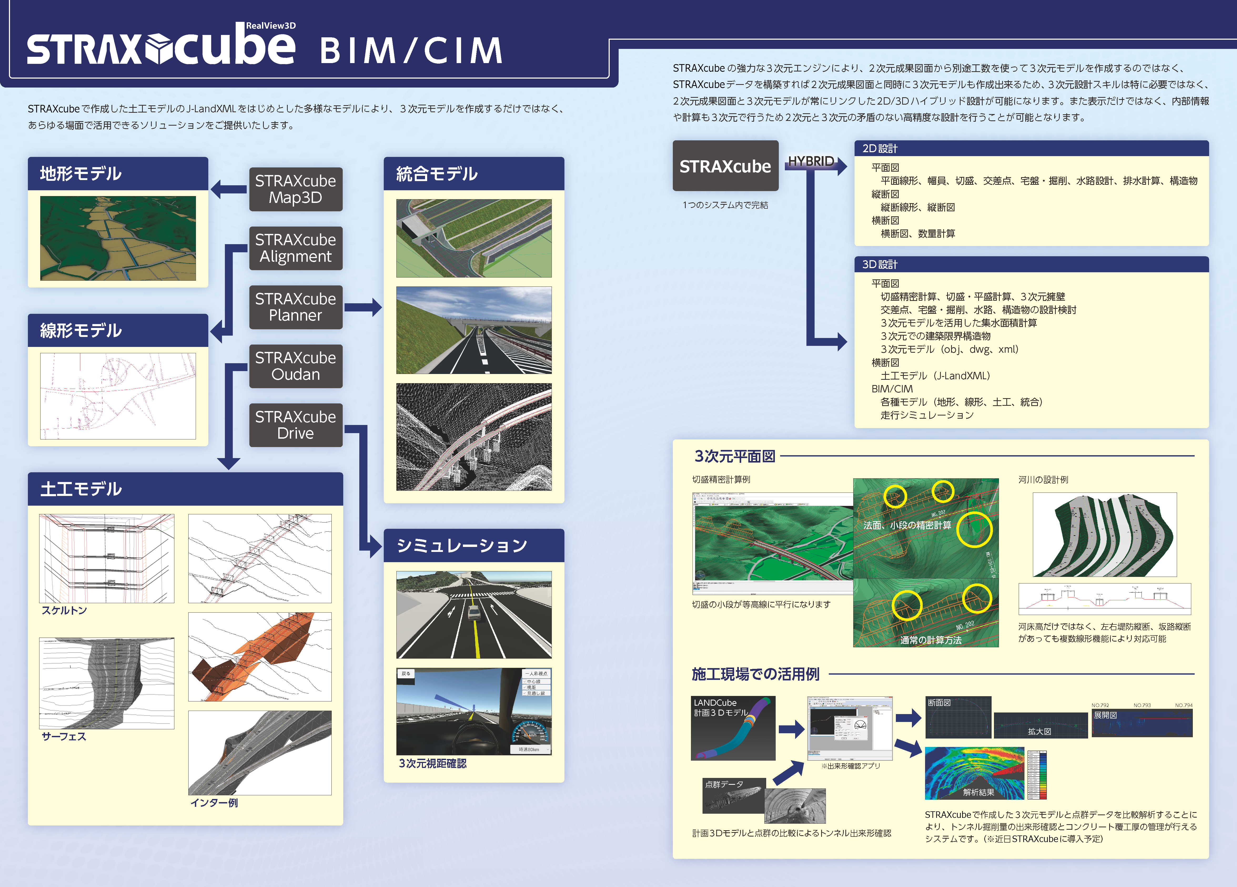
STRAXcubeは、設計検討や2次元設計成果図面と3Dモデルがリンクした2D-3Dのハイブリッド設計を実現する、3D道路土木設計システムです。
内部データは全て3次元で情報を構築しており、例えば線形、縦断や幅員構成、現況地形などを変更した場合、成果図面も数量計算も3Dモデルも瞬時に更新されるので、現状の2Dと3Dが分断された作業となるBIM/CIM設計から解放されます。
3次元設計するための主な機能
・本線、ランプ、側道などの複数線形間で、路面、法面、擁壁の3次元精密計算
・十字、T字、H型、ラウンドアバウト、取付けなど、あらゆるタイプの交差点をひとつの画面で3次元設計
・複雑な構造物データの取込、ウィングと路肩と法面を考慮した巻き込み部の擁壁計算
・平面図での水路・桝の設置、集水面積を求めて排水計算も3次元設計
・設計成果図面、数量計算、3Dモデルの連携
STRAXcube is a 3D civil engineering design system for roads that combines 2D and 3D design. It links 3D models with design studies and 2D drawings.
The internal data is constructed in 3D. When changes are made to plane alignment, vertical alignment, width configuration, or existing topography, the 3D model, resulting drawings, and quantity calculations are instantly updated. This frees the user from the current BIM/CIM design process where 2D and 3D are separated.
Main Functions of STRAXcube
Accurately calculate 3D road surfaces, slopes, and retaining walls for various alignments, including main lines, ramps, and side roads.
It also includes 3D design for all types of intersections, such as cross, T-shape, H-shape, roundabout, and installation on a single screen.
Additionally, it covers retaining wall calculations for complex structures, including wings, shoulders, and
slopes, as well as 3D design of waterways and catch basins on plan view, and drainage calculations by determining the catchment area.
Finally, it mentions the linkage of design drawings, quantity calculations, and 3D models.

REDcube(舗装点検ソリューション)
REDcube "Pavement inspection"
路面性状調査専用車両ではない、通常のMMSにて路面性状解析調査を行います。
MMS前方もしくは後方に搭載されたカメラで撮影した画像データをもとにAIを活用してひび割れを自動トレースし、Z&F製高密度レーザースキャナで計測した点群データを用いてわだち掘れと平たん性(IRI)を解析することができます。
Pavement inspections are carried out using the Mobile Mapping System.
Inspections include pavement cracks, ruts, flatness, IRI and evaluation maps using AI.

除雪支援システム
Snow Removal Support System
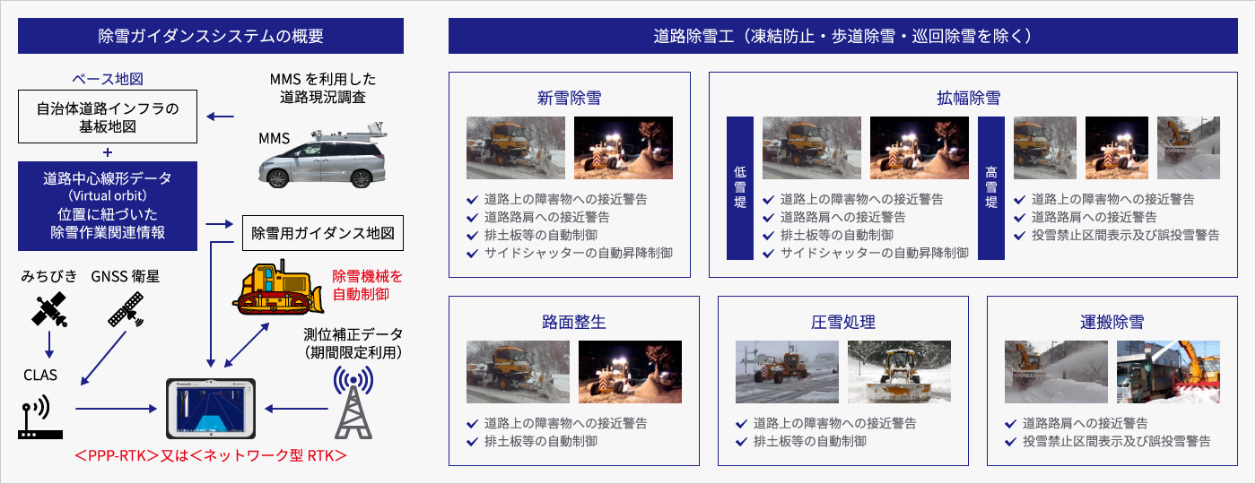
除雪作業時の縁石・マンホール等の地物表示、対象物への接近警告からなるガイダンスシステム、除雪装置の自動化システムです。
近年、豪雪地帯の自治体などでは熟練オペレータの高齢化や担い手不足等の課題に対して、将来にわたって安定的な除雪体制を確保することが喫緊の課題となっています。我々はオペレータの経験不足を補うだけではなく、一人のオペレータでも安全性を確保しながら除雪機械を自動制御できる姿を目指しています。
この問題を解決するために、MMSやドローン等の点群やカメラ情報を元に作成した高精度3D地図と、1周波RTK-GNSSなど高精度に位置測位が出来るシステムを組み合わせています。さらに除雪装置の自動化などに取り組み安全性の向上も目指しています。
This is an automated system for snow removal equipment and a guidance system that displays geographical objects, such as curbs and manholes, during snow removal operations. It also provides warnings of approaching objects.
In recent years, municipalities in areas with heavy snowfalls have faced the urgent task of ensuring a stable snow removal system for the future due to the aging of skilled operators and a lack of personnel. Our objective is not only to compensate for the shortage of experienced operators but also to attain automatic control of snow removal equipment while ensuring safety even with only one operator.
To address this issue, we combine high-precision 3D maps created from point clouds and camera information from MMS, drones, etc., with highly accurate positioning systems such as single-frequency RTK-GNSS. We are also striving to enhance safety by automating snow removal equipment.
