基本情報
出展製品・サービス
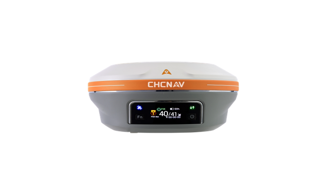
i93ビジュアル IMU-RTK
i93VISUAL IMU-RTK
GNSSアンテナ
IMU、カメラを搭載したGNSSアンテナです。同社I83GNSSと同様の座標観測機能の他に、カメラを用いたAR杭打ち機能、ビジュアルサーベイ機能、写真測量機能、平面図作成機能を有しているのが大きな特徴です。また、Beidowを補足することで水平、高さ共に精度の高いデータ取得が可能です。バッテリーは本体内蔵、Android搭載の専用送信機が付属しているため非常に扱いやすい仕様となっています。
The i93 GNSS receiver is an extremely versatile RTK that integrates the latest GNSS, IMU, and premium dual-camera
technologies for a more compelling user experience. Its 3D visual stakeout feature provides unparalleled ease of use
and comfort, boosting efficiency for any construction site layout project. Visual survey with video-photogrammetry
technology enables accurate point measurements and access to previously hard-to-reach, signal obstructed, and
hazardous points. The i93 GNSS can be used to complement aerial surveys generated from oblique imagery
since its data is compatible with the most popular 3D modeling software. The i93 GNSS receiver is powered by the
innovative CHCNAV iStar GNSS RTK algorithm, multi-band GNSS channels, and hybrid engine for reliable, high
accuracy positioning in even the most challenging site conditions. The Auto-IMU of i93 features automatic initialization,
eliminating the hassle of manual initialization and simplifying surveying operations in the field. The i93 is the ideal
solution for completing tasks faster, more accurately, and more efficiently.

AA10 LiDARシステム
AlphaAir 10
UAV専用ハイスペックLiDARシステムです。毎秒50万点の計測、リターン回数は8回あり、対地高度120mで運用可能です。4500万画素のカメラ付きで1.6Kgの軽量設計であるため、DJI社製Matrice300・350にワンタッチで取り付け、効率良く計測が行えます。また専用ソフトCopreで、点群生成からフィルタリング、3次元モデル作成まで一貫して行うことができます。
The AlphaAir 10 is an advanced aerial surveying solution that seamlessly integrates LiDAR and RGB
sensors to meet the needs of professional UAV LiDAR mapping and drone photogrammetry. Leveraging
CHCNAV’s cutting-edge LiDAR technology, the AA10 flawlessly integrates high-precision LiDAR, accurate
GNSS positioning, IMU orientation and an industrial-grade full-frame orthophoto camera. Combined with
CHCNAV point cloud and image fusion modeling software, the AA10 provides a survey-grade, efficient
and cost-effective approach to 3D data acquisition and processing. The AA10 Airborne LiDAR + RGB
System accelerates accurate 3D data collection within a single mission and simplifies the process of
capturing 3D reality through a streamlined workflow.

TX63 3D パワーショベルガイダンスシステム
TX63 3D MACHINE GUIDANCE FOR EXCAVATOR
掘削機ガイダンスシステム「CHCNAV TX63」は、掘削作業の品質と効率を向上させます。
高精度デュアル GNSS、IMU、EX-Tech メカニカルモデルアルゴリズムを組み合わせることで、信頼性の高い 3D
ポジショニングとバケット位置を示すヘディングを提供します。
リアルタイムガイダンスにより、オペレーターはより短時間で、より正確にバケットを設計面に制御することがで
き、手作業によるステーキングを排除することで効率と生産性を向上させます。
産業用タッチスクリーンは、オペレーターの指先にシステムを配置します。MCNAV ソフトウェアは、マシン
オペレーターに包括的でユーザーフレンドリーなガイダンスを提供します。プロジェクト設定、カット&フィル
データ、ジオフェンシングゾーンなどのジョブ情報を詳細に表示し、常に一目で確認することが可能です。
The CHCNAV TX63 excavator guidance system increases the precision and efficiency of excavation work. By
integrating high accuracy dual-GNSS, an IMU sensor and the power of EX-Tech’s mechanical model algorithm, it
provides reliable 3D positioning and heading information to accurately indicate the bucket’s position.
With real-time guidance, operators can quickly and accurately steer the bucket to the design surface in less time
and with greater accuracy. By eliminating the need for manual staking, the system maximizes operational efficiency
and productivity. The industrial touchscreen places the system’s controls within easy reach of the operator. The
MCNAV software provides comprehensive and easy-to-use guidance with detailed displays of job information,
including project setup, cut and fill data and geo-fencing zones - all accessible at a glance.
