基本情報
出展製品・サービス
掘削状況3D管理アプリ ちかデジ®
Digital Infrastructure Guide & Survey
地下情報デジタライズ 掘削状況3D管理アプリ:ちかデジ®
一般的な工事では、掘削完了後、埋設状況を検尺し、手書きスケッチと共に写真撮影を行います。
その後、それらのデータを清書(CAD化)しているため、出来形管理の時間・労力の増加、
記録ミス等の課題があります。
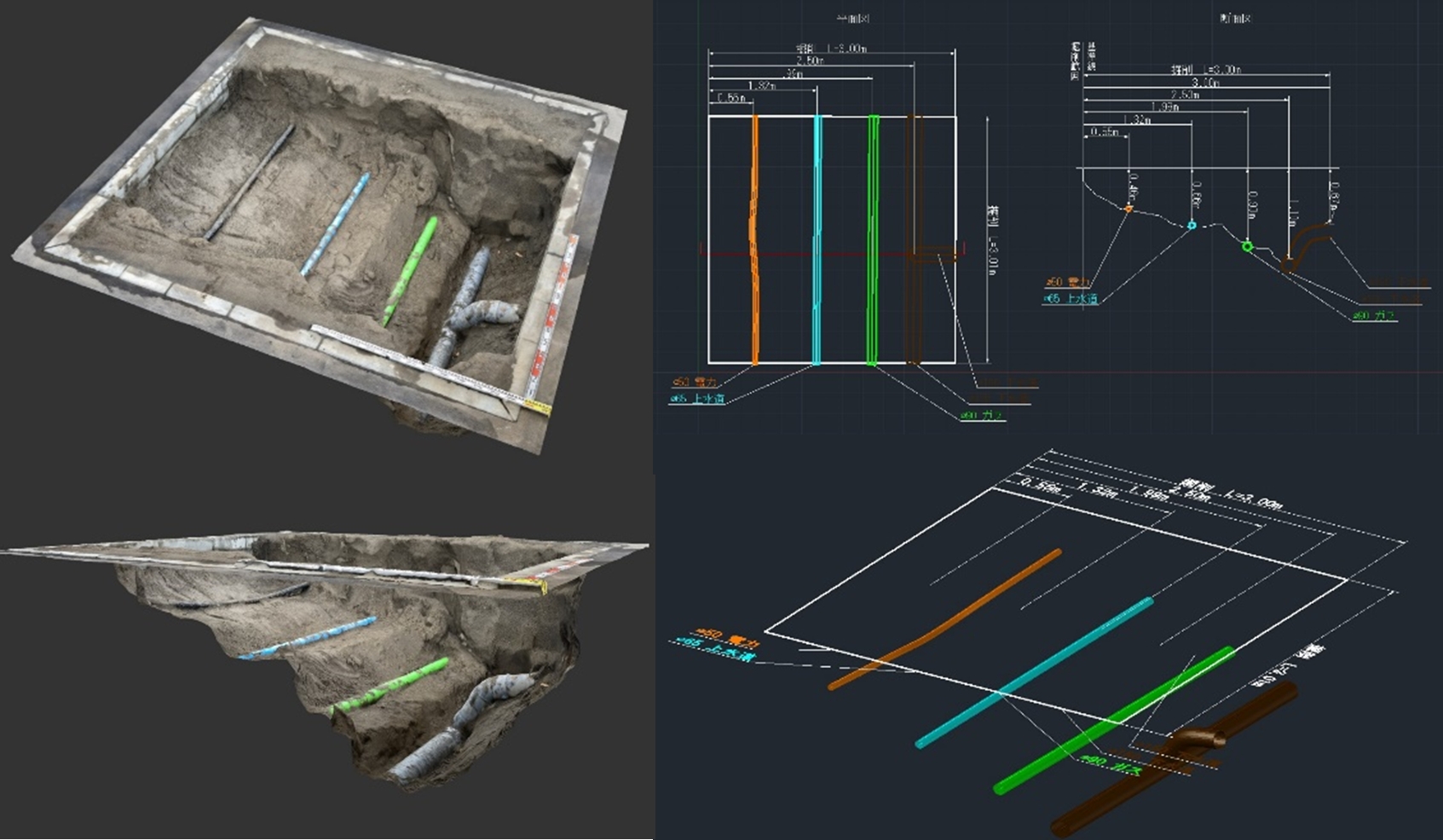
ちかデジ®は、掘削状況をスマートフォン、タブレットなどのデバイスを用いて撮影した
動画データを専用のWebアプリに登録することで3Dデジタル化し、掘削状況を視認性の高いデータで
記録することができる技術です。
Webアプリで登録された動画データは、社内システムで3Dデータ化し、再びアプリに登録されます。
登録されるデータは、3Dモデリングデータ、点群データ、平面図、断面図、ARデータなど様々な
デジタルデータとなり、地図情報プラットフォーム(GIS)で一元管理することが可能です。
また、作業が省力化されることで労働時間が削減されるので、働き方改革にも繋がります。
【効果・活用事例】
・標準的なスマートフォン・タブレットで簡単撮影
・専用Webアプリでデータの投稿と閲覧が可能
・掘削結果を3Dで直観的に把握できる
・測距機能で深さ、距離などの計測可能
・地図情報プラットフォームで一元管理が可能
・労働時間削減で働き方改革にも繋がる
・国土交通省 NETIS登録番号:KT-220240-A
Excavation Condition 3D Management App: Chika-Digi
In typical construction work, after excavation is completed, the underground condition is measured, and photographs are taken along with hand-drawn sketches.
This is a technology that can record excavation conditions as highly visible data by digitizing a video.
A device such as a smartphone or tablet can be used to record, upload, and submit the video to the web app to create 3D digital data.
The video is converted into 3D data using our company’s internal system and then resubmitted to the app.
The resubmitted data can come in various digital formats such as 3D modeling data, point cloud data, plan views, cross-sectional views, AR data, etc., and can be centrally managed using the map information platform GIS.
In addition, labor-saving nature of the work reduces working hours, thus improving labor conditions.
[Advantages and Usage]
*Only a smartphone or tablet is required.
*Data can be posted and viewed in the app.
*3D excavation results are intuitive.
*Depth, distance, etc. can be measured with the measurement tool.
*Centralized management is possible on the platform.
*Reduced working hours can lead to an improved work style.
*Ministry of Land, Infrastructure, Transport and Tourism NETIS registration number: KT-220240-A

地上・地下インフラ3Dマップ®
Non-intrusive 3D exploration of underground objects
地下埋設物を地上から3次元で正確に探査する新技術:地上・地下インフラ3Dマップ®
地上・地下インフラ3Dマップ®は、地下の正確な埋設物3Dデータと、
地上の道路・建物などの3Dデータを統合し、現地再現性の高い地下可視化する技術です。
一般的な地下埋設物探査は道路進行方向に対し断面方向の計測のみを行うため、
情報量が少なくなります。地上・地下インフラ3Dマップ®は、多配列アンテナで地下情報の
三次元データを取得することで情報量も多く、精度の高いデータを取得することが可能です。
取得した3Dデータを設計・調整・施工・管理の全ての工程で活用することにより、手もどり防止に
よる工事の効率化と安全施工につながります。さらに、AR技術を活用した現地作業の簡素化や
試掘を削減することもできます。
【効果・活用事例】
・3Dマップは、一般的なCADとしてもアウトプット可能
・地下埋設物の距離、確度、高さ、深さも計測可能
・3Dマップを活用した設計で既存埋設管との干渉チェックやシミュレーションが可能
・関係者全員が工事前に地下の埋設状況を三次元で把握可能
・工事完了後の埋設物状況を3Dマップに取り込むことで地下情報を正確に更新可能
・AR技術を用いて現地で埋設物敷設状況を再現可能
・国土交通省 NETIS登録番号:KT-180111-VE
Non-intrusive 3D Exploration of Underground Objects
This technology integrates accurate 3D underground data of buried objects with 3D aboveground data of roads, buildings, etc. to create an underground visualization with high on-site reproducibility.
Typical buried object exploration only measures the cross section in the direction of travel, so little information is acquired.
With this technology, it is possible to acquire a large amount of information and by acquiring highly accurate 3D data of the underground by using multi-array antennas. By utilizing the acquired 3D data in all processes of design, adjustment, construction, and management, a safer and more efficient construction can be achieved by preventing rework.
Additionally, AR technology simplifies on-site work and reduces trial excavations.
[Advantages and Usage]
*3D maps can be output as CAD.
*Measurement of the distance, accuracy, height, and depth of objects is possible.
*Interference with existing buried pipes can be simulated.
*All concerned members can view the underground condition in three dimensions prior to construction.
*Underground information can be accurately updated by incorporating post-construction buried object conditions into a 3D map.
*Ministry of Land, Infrastructure, Transport and Tourism NETIS registration number: KT-180111-VE

スケルカビューDX®
Bridge Deck Inspection
目に見えない舗装・橋梁床版内の劣化を調査:スケルカビューDX®
これまでに蓄積した解析の知見をベースに構築した高精度AIと画像処理技術を駆使した
定量的評価を活用して専門技術者が解析することで、高度な床版健全性の判定が可能になりました。
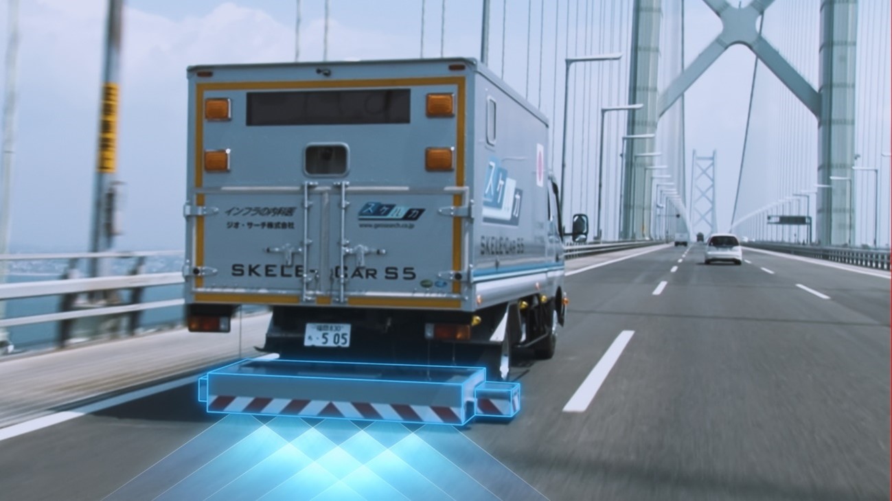
最高速度100km/hで取得した橋梁床版や舗装内部のデータをスピーディーに解析し、診断カルテを作成します。橋梁床版の劣化箇所を把握し、補修設計・施工の生産性向上に貢献します。
【効果・活用事例】
・マイクロ波で舗装・橋梁床版内部の劣化を早期発見可能
・最高速度100km/hでデータ取得可能
・省人化、省力化が推進し、費用対効果を高めることが可能
・データベース化し、点検データの一元管理可能
・国土交通省 NETIS登録番号:HK-230016-A
・国土交通省 点検支援技術カタログ掲載番号:BR-020014-V0223
Bridge Deck Inspection
By utilizing quantitative evaluations based high-precision AI and image processing technology built on the knowledge of analysis accumulated to date, it is now possible for specialized engineers to analyze and make advanced determinations on floor slab health.
This quickly analyzes data, which is acquired at a maximum speed of 100km/h, and creates a diagnostic chart of the bridge deck and pavement interiors.
It helps to identify deteriorated parts of bridge decks and improves productivity in repair design and construction.
[Advantages and Usage]
*Early detection of deterioration inside pavement and bridge deck slabs is possible using microwaves.
*Data can be acquired at a maximum speed of 100km/h.
*Increasing cost effectiveness by promoted labor saving is possible.
*Centrally manage inspection data by creating a database.
*Ministry of Land, Infrastructure, Transport and Tourism NETIS registration number: HK-230016-A
*Ministry of Land, Infrastructure, Transport and Tourism Inspection Support Technology Catalog Publication Number: BR-020014-V0223
